IMAGES TAKEN NEAR TO
Duncton, PETWORTH, GU28 0QR
Introduction
This page details the photographs taken nearby to GU28 0QR by members of the Geograph project.
The Geograph project started in 2005 with the aim of publishing, organising and preserving representative images for every square kilometre of Great Britain, Ireland and the Isle of Man.

There are currently over 7.5m images from over14,400 individuals and you can help contribute to the project by visiting https://www.geograph.org.uk
Image Map
Images are licensed for reuse under creativecommons.org/licenses/by-sa/2.0
Notes
- Clicking on the map will re-center to the selected point.
- The higher the marker number, the further away the image location is from the centre of the postcode.
Image Listing (6 Images Found)
Images are licensed for reuse under creativecommons.org/licenses/by-sa/2.0
Image
Details
Distance
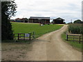
2
Barn at Ridlington Farm
On a sandy rise, there is little mud about, but could be quite dusty.
Image: © Robin Webster
Taken: 13 Oct 2010
0.04 miles
4
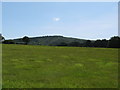
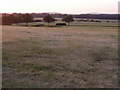
Green pastures at Ridlington Farm
Duncton Hanger on the horizon
Image: © Dave Spicer
Taken: 22 Aug 2009
0.19 miles
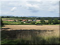
5
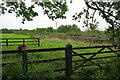
Fields west of Duncton village
Taken on the public footpath leading to Ridlington Farm.
Image: © chris pearson
Taken: 12 Jul 2006
0.19 miles
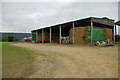
6
Row of open stalls, apparently disused, Westerland Farm, 2010
The fencing (later removed) suggests this is to do with horses, but I can't think what.
Image: © Robin Webster
Taken: 13 Oct 2010
0.20 miles