IMAGES TAKEN NEAR TO
Graffham, PETWORTH, GU28 0QJ
Introduction
This page details the photographs taken nearby to GU28 0QJ by members of the Geograph project.
The Geograph project started in 2005 with the aim of publishing, organising and preserving representative images for every square kilometre of Great Britain, Ireland and the Isle of Man.

There are currently over 7.5m images from over14,400 individuals and you can help contribute to the project by visiting https://www.geograph.org.uk
Image Map
Images are licensed for reuse under creativecommons.org/licenses/by-sa/2.0
Notes
- Clicking on the map will re-center to the selected point.
- The higher the marker number, the further away the image location is from the centre of the postcode.
Image Listing (3 Images Found)
Images are licensed for reuse under creativecommons.org/licenses/by-sa/2.0
Image
Details
Distance
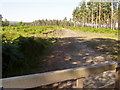
2
The Serpent Trail on access land at Lavington Common
Public footpath 672/2 continues ahead whilst path 3533 proceeds left to Lower Barn. The Serpent Trail is a 64 mile long distance footpath from Haslemere to Petersfield. The route is designed to join up the many heathland areas on greensand in the western Weald.
Image: © Peter Holmes
Taken: 16 Apr 2016
0.22 miles
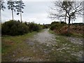
3
The Serpent Trail on Lavington Common
Public footpath 672/2 on access land. The Serpent Trail is a 64 mile long distance footpath from Haslemere to Petersfield. The route is designed to join up the many heathland areas on greensand in the western Weald.
Image: © Peter Holmes
Taken: 16 Apr 2016
0.25 miles