IMAGES TAKEN NEAR TO
Selham, PETWORTH, GU28 0PL
Introduction
This page details the photographs taken nearby to GU28 0PL by members of the Geograph project.
The Geograph project started in 2005 with the aim of publishing, organising and preserving representative images for every square kilometre of Great Britain, Ireland and the Isle of Man.

There are currently over 7.5m images from over14,400 individuals and you can help contribute to the project by visiting https://www.geograph.org.uk
Image Map
Images are licensed for reuse under creativecommons.org/licenses/by-sa/2.0
Notes
- Clicking on the map will re-center to the selected point.
- The higher the marker number, the further away the image location is from the centre of the postcode.
Image Listing (121 Images Found)
Images are licensed for reuse under creativecommons.org/licenses/by-sa/2.0
Image
Details
Distance
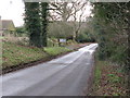
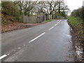
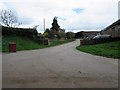
2
Road junction in Selham
The smaller road on the left leads to Midhurst via South Ambersham
Image: © Dave Spicer
Taken: 27 Dec 2009
0.05 miles
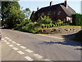
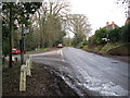
4
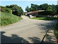
Entrance to Hurlands Farm Selham
Also a bridleway that takes you onto part of the dismantled Midhurst to Pulborough line.
Image: © Dave Spicer
Taken: 31 Jul 2011
0.09 miles
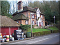
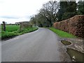
5
Bridleway to Fitzlea Farm
Public bridleway 3350 through Hurlands Farm.
Image: © Peter Holmes
Taken: 16 Apr 2016
0.10 miles