IMAGES TAKEN NEAR TO
Graffham, PETWORTH, GU28 0NY
Introduction
This page details the photographs taken nearby to GU28 0NY by members of the Geograph project.
The Geograph project started in 2005 with the aim of publishing, organising and preserving representative images for every square kilometre of Great Britain, Ireland and the Isle of Man.

There are currently over 7.5m images from over14,400 individuals and you can help contribute to the project by visiting https://www.geograph.org.uk
Image Map
Images are licensed for reuse under creativecommons.org/licenses/by-sa/2.0
Notes
- Clicking on the map will re-center to the selected point.
- The higher the marker number, the further away the image location is from the centre of the postcode.
Image Listing (20 Images Found)
Images are licensed for reuse under creativecommons.org/licenses/by-sa/2.0
Image
Details
Distance
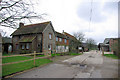
1
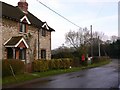
Road junction at Marsh Cottage near Marsh Farm
The picture is from the private road which serves as a public footpath.
Image: © Shazz
Taken: 17 Feb 2011
0.02 miles
2
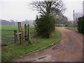
Stile near Marsh Farm
The red notice is an upside down danger sign.
Image: © Shazz
Taken: 17 Feb 2011
0.02 miles
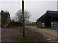
5
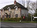
Woodcote Farm, Graffham
At the end of a short public road. The sign indicates also that a private road continues to Hayland Farm.
Image: © Robin Webster
Taken: 13 Feb 2007
0.07 miles
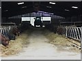
8
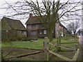
Farmyard with footpath signs
This is at Woodcote Farm.
Image: © Shazz
Taken: 17 Feb 2011
0.08 miles

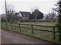
10
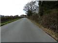
Un-named road approaching Marsh Cottage
The small collections of houses are called Woodcote.
Image: © Dave Spicer
Taken: 6 Mar 2012
0.09 miles