IMAGES TAKEN NEAR TO
Graffham, PETWORTH, GU28 0NT
Introduction
This page details the photographs taken nearby to GU28 0NT by members of the Geograph project.
The Geograph project started in 2005 with the aim of publishing, organising and preserving representative images for every square kilometre of Great Britain, Ireland and the Isle of Man.

There are currently over 7.5m images from over14,400 individuals and you can help contribute to the project by visiting https://www.geograph.org.uk
Image Map
Images are licensed for reuse under creativecommons.org/licenses/by-sa/2.0
Notes
- Clicking on the map will re-center to the selected point.
- The higher the marker number, the further away the image location is from the centre of the postcode.
Image Listing (13 Images Found)
Images are licensed for reuse under creativecommons.org/licenses/by-sa/2.0
Image
Details
Distance
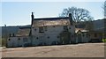
1
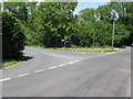
T junction in Graffham
The road to the left leads to Heyshott.
Image: © Dave Spicer
Taken: 26 Jun 2010
0.10 miles
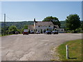
8
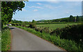
Country road near Graffham (4)
Hardly a country road actually, just a short metalled section leading to a car park at the recreation ground. The top of a goal is just visible above the hedge.
The South Downs in the background.
Image: © Stephen Richards
Taken: Unknown
0.22 miles