IMAGES TAKEN NEAR TO
Droke Lane, PETWORTH, GU28 0LY
Introduction
This page details the photographs taken nearby to Droke Lane, GU28 0LY by members of the Geograph project.
The Geograph project started in 2005 with the aim of publishing, organising and preserving representative images for every square kilometre of Great Britain, Ireland and the Isle of Man.

There are currently over 7.5m images from over14,400 individuals and you can help contribute to the project by visiting https://www.geograph.org.uk
Image Map
Images are licensed for reuse under creativecommons.org/licenses/by-sa/2.0
Notes
- Clicking on the map will re-center to the selected point.
- The higher the marker number, the further away the image location is from the centre of the postcode.
Image Listing (11 Images Found)
Images are licensed for reuse under creativecommons.org/licenses/by-sa/2.0
Image
Details
Distance
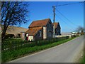
4
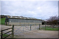
Barn by Droke Lane
This is just one of several farm buildings here, unnamed even on the OS 1:10000 map.
Image: © Robin Webster
Taken: 12 Feb 2007
0.07 miles
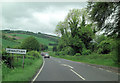
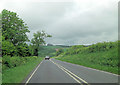
7
Minor road junction with the A285 near Droke
Image: © Dave Spicer
Taken: 11 Jul 2010
0.16 miles
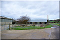
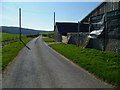
8
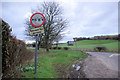
Droke Lane junction with A285
Some joker has reversed the width limit sign. Note the snowdrops.
Image: © Robin Webster
Taken: 12 Feb 2007
0.17 miles
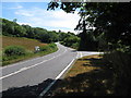
9
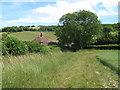
Tree by the footpath exit onto the A285
Image: © Dave Spicer
Taken: 11 Jul 2010
0.24 miles