IMAGES TAKEN NEAR TO
Graffham, PETWORTH, GU28 0LR
Introduction
This page details the photographs taken nearby to GU28 0LR by members of the Geograph project.
The Geograph project started in 2005 with the aim of publishing, organising and preserving representative images for every square kilometre of Great Britain, Ireland and the Isle of Man.

There are currently over 7.5m images from over14,400 individuals and you can help contribute to the project by visiting https://www.geograph.org.uk
Image Map
Images are licensed for reuse under creativecommons.org/licenses/by-sa/2.0
Notes
- Clicking on the map will re-center to the selected point.
- The higher the marker number, the further away the image location is from the centre of the postcode.
Image Listing (4 Images Found)
Images are licensed for reuse under creativecommons.org/licenses/by-sa/2.0
Image
Details
Distance
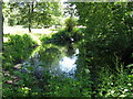
1
Bridleway at Birch Copse
The bridleway leaves the roadside at Birch Copse and heads northwards to meet up with the Serpent Trail.
Image: © Chris Thomas-Atkin
Taken: 19 Aug 2021
0.09 miles
2
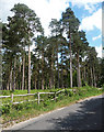
Woodland near Graffham
A plantation of what look like Scots pines, beside the road to Graffham.
Image: © Stephen Richards
Taken: Unknown
0.18 miles
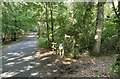
3
Birch Copse
Passing through Birch Copse on the bridleway heading northwards to join with the Serpent Trail.
Image: © Chris Thomas-Atkin
Taken: 19 Aug 2021
0.19 miles