IMAGES TAKEN NEAR TO
Rotherbridge Lane, PETWORTH, GU28 0LL
Introduction
This page details the photographs taken nearby to Rotherbridge Lane, GU28 0LL by members of the Geograph project.
The Geograph project started in 2005 with the aim of publishing, organising and preserving representative images for every square kilometre of Great Britain, Ireland and the Isle of Man.

There are currently over 7.5m images from over14,400 individuals and you can help contribute to the project by visiting https://www.geograph.org.uk
Image Map
Images are licensed for reuse under creativecommons.org/licenses/by-sa/2.0
Notes
- Clicking on the map will re-center to the selected point.
- The higher the marker number, the further away the image location is from the centre of the postcode.
Image Listing (29 Images Found)
Images are licensed for reuse under creativecommons.org/licenses/by-sa/2.0
Image
Details
Distance
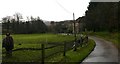
2
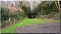
Hungers Lane
Looking up Hungers Lane from Rotherbridge Lane. Hungers Lane was once the turnpike between Chichester and Petworth.
Image: © Shazz
Taken: 19 Dec 2008
0.02 miles

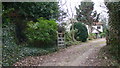
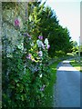
4
Rotherbridge Lane approaching Rotherbridge Farm
Image: © Dave Spicer
Taken: 22 Aug 2009
0.03 miles
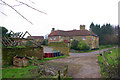
5
Rotherbridge Lane arrives at Rotherbridge Farm
Image: © Shazz
Taken: 19 Dec 2008
0.04 miles
7
Rotherbridge Farm
Viewed from the end of the Rother bridge, crossed by a bridleway.
Image: © Robin Webster
Taken: 19 Feb 2007
0.06 miles
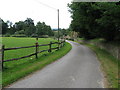
8
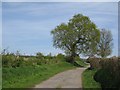
Rotherbridge Lane
Lane leading from Rotherbridge Farm towards the A283.
Image: © Ben Gamble
Taken: 26 Apr 2008
0.07 miles
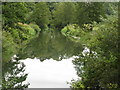
9
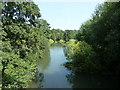
Downstream on the River Rother at Rotherbridge Farm
Image: © Dave Spicer
Taken: 31 Jul 2011
0.08 miles