IMAGES TAKEN NEAR TO
Burton Park Road, PETWORTH, GU28 0JT
Introduction
This page details the photographs taken nearby to Burton Park Road, GU28 0JT by members of the Geograph project.
The Geograph project started in 2005 with the aim of publishing, organising and preserving representative images for every square kilometre of Great Britain, Ireland and the Isle of Man.

There are currently over 7.5m images from over14,400 individuals and you can help contribute to the project by visiting https://www.geograph.org.uk
Image Map
Images are licensed for reuse under creativecommons.org/licenses/by-sa/2.0
Notes
- Clicking on the map will re-center to the selected point.
- The higher the marker number, the further away the image location is from the centre of the postcode.
Image Listing (9 Images Found)
Images are licensed for reuse under creativecommons.org/licenses/by-sa/2.0
Image
Details
Distance
2
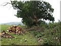
Log pile following a broken bough on large Oak
Image: © Dave Spicer
Taken: 22 Aug 2009
0.07 miles
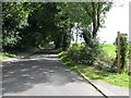
5
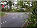
Road junction with the A285 near Duncton Common
Image: © Shazz
Taken: 15 Apr 2011
0.20 miles
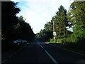
8
View west along the path NW of Black Pond
Image: © Ian Hawfinch
Taken: 15 Mar 2021
0.23 miles
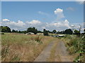
9
View along the path north of Black Pond
The path (heading west) can be seen on the left.
Image: © Ian Hawfinch
Taken: 15 Mar 2021
0.24 miles