IMAGES TAKEN NEAR TO
Stoney Hill, Station Road, PETWORTH, GU28 0JA
Introduction
This page details the photographs taken nearby to Stoney Hill, Station Road, GU28 0JA by members of the Geograph project.
The Geograph project started in 2005 with the aim of publishing, organising and preserving representative images for every square kilometre of Great Britain, Ireland and the Isle of Man.

There are currently over 7.5m images from over14,400 individuals and you can help contribute to the project by visiting https://www.geograph.org.uk
Image Map
Images are licensed for reuse under creativecommons.org/licenses/by-sa/2.0
Notes
- Clicking on the map will re-center to the selected point.
- The higher the marker number, the further away the image location is from the centre of the postcode.
Image Listing (16 Images Found)
Images are licensed for reuse under creativecommons.org/licenses/by-sa/2.0
Image
Details
Distance
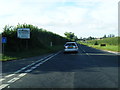
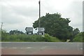
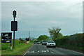
2
Junction of Haslingbourne Lane with the A 285
Obviously the red tarmac doesn't slow the drivers, it just makes the skid marks more visible
Image: © Dave Spicer
Taken: 22 Aug 2009
0.12 miles
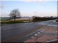
3
Crossroads on the A285 south of Petworth
Image: © David Howard
Taken: 3 Aug 2015
0.13 miles
4
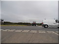
Crossroads on the A285 south of Petworth
Image: © David Howard
Taken: 3 Aug 2015
0.13 miles
6
Crossroads at Haslingbourne ( A285 )
Image: © Stephen Howard
Taken: 24 Jan 2007
0.14 miles
7
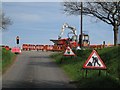
Roadworks at Crossroads
Where the A283 intersects Rotherbridge Lane and Haslingbourne Lane, roadworks are under way, requiring 4-way traffic lights.
Image: © Ben Gamble
Taken: 26 Apr 2008
0.14 miles
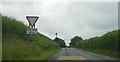
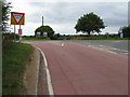
9
Lorry routes around Petworth
On the A285 heading towards Chichester, away from Petworth. For other destinations a left turn should be made.
Image: © Robin Webster
Taken: 19 May 2012
0.18 miles
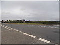
10
Rotherbridge Lane and bridleway west from the A 285
Image: © Dave Spicer
Taken: 22 Aug 2009
0.18 miles