IMAGES TAKEN NEAR TO
Byworth, PETWORTH, GU28 0HW
Introduction
This page details the photographs taken nearby to GU28 0HW by members of the Geograph project.
The Geograph project started in 2005 with the aim of publishing, organising and preserving representative images for every square kilometre of Great Britain, Ireland and the Isle of Man.

There are currently over 7.5m images from over14,400 individuals and you can help contribute to the project by visiting https://www.geograph.org.uk
Image Map
Images are licensed for reuse under creativecommons.org/licenses/by-sa/2.0
Notes
- Clicking on the map will re-center to the selected point.
- The higher the marker number, the further away the image location is from the centre of the postcode.
Image Listing (6 Images Found)
Images are licensed for reuse under creativecommons.org/licenses/by-sa/2.0
Image
Details
Distance
1
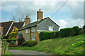
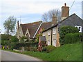
Cottage, Byworth
To the left is an old school.
Image: © Robin Webster
Taken: 20 Apr 2012
0.18 miles
2
Post Box
GU28 57 Hungers Corner (Byworth)
Image: © The Saunterer
Taken: 20 Nov 2012
0.21 miles
3
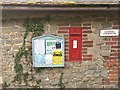
Byworth wall postbox
Wall postbox outside Edgehill Farm, with adjacent village notice board. Wider perspective: Image
Image: © Hugh Craddock
Taken: 28 Aug 2017
0.21 miles
4
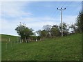
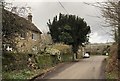
Footpath to Byworth
Climbing from the Haslingbourne up towards Byworth.
Image: © Ben Gamble
Taken: 26 Apr 2008
0.21 miles
5
Byworth
Houses in the hamlet of Byworth, near Petworth.
Image: © Ben Gamble
Taken: 26 Apr 2008
0.21 miles
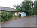
6
Hallgate Farm
Hallgate Farm in Byworth.
Image: © Chris Thomas-Atkin
Taken: 5 Jan 2020
0.24 miles