IMAGES TAKEN NEAR TO
Horsham Road, PETWORTH, GU28 0HB
Introduction
This page details the photographs taken nearby to Horsham Road, GU28 0HB by members of the Geograph project.
The Geograph project started in 2005 with the aim of publishing, organising and preserving representative images for every square kilometre of Great Britain, Ireland and the Isle of Man.

There are currently over 7.5m images from over14,400 individuals and you can help contribute to the project by visiting https://www.geograph.org.uk
Image Map
Images are licensed for reuse under creativecommons.org/licenses/by-sa/2.0
Notes
- Clicking on the map will re-center to the selected point.
- The higher the marker number, the further away the image location is from the centre of the postcode.
Image Listing (9 Images Found)
Images are licensed for reuse under creativecommons.org/licenses/by-sa/2.0
Image
Details
Distance
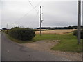
1
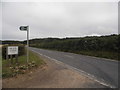
The entrance to Moor Farm on Horsham Road
Image: © David Howard
Taken: 3 Aug 2015
0.00 miles
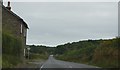
6
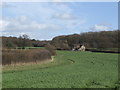
Wooded countryside
East of Petworth and just north of the A272.
Image: © Jonathan Billinger
Taken: 1 Mar 2007
0.10 miles
7
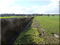
Flat land east of Petworth
The drainage ditch and hedge leads the eye to the woods in the distance; part of the Petworth House estate.
Image: © Jonathan Billinger
Taken: 1 Mar 2007
0.12 miles
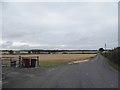
8

Drive to Moor Farm from the A272 near Petworth
This part of the drive is also a public bridleway. Moor Farm can be seen about half a mile from the camera in the next grid square to the north.
Image: © Shazz
Taken: 30 Apr 2010
0.13 miles