IMAGES TAKEN NEAR TO
Rothermead, PETWORTH, GU28 0EW
Introduction
This page details the photographs taken nearby to Rothermead, GU28 0EW by members of the Geograph project.
The Geograph project started in 2005 with the aim of publishing, organising and preserving representative images for every square kilometre of Great Britain, Ireland and the Isle of Man.

There are currently over 7.5m images from over14,400 individuals and you can help contribute to the project by visiting https://www.geograph.org.uk
Image Map
Images are licensed for reuse under creativecommons.org/licenses/by-sa/2.0
Notes
- Clicking on the map will re-center to the selected point.
- The higher the marker number, the further away the image location is from the centre of the postcode.
Image Listing (8 Images Found)
Images are licensed for reuse under creativecommons.org/licenses/by-sa/2.0
Image
Details
Distance
1
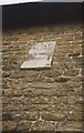
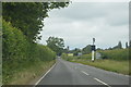
Old Milestone by the A285, Station Road
Carved stone plaque by the A285, in parish of PETWORTH (CHICHESTER District), Station Road, on an old stone cottage, close to the highway, first floor level facing the highway, on West side of road. Petworth plaque, erected by the Petworth turnpike trust in the 19th century.
Inscription reads:-
50
MILES
From
LONDON
Milestone Society National ID: SX_LMP50.
Image: © Colin Woodward
Taken: Unknown
0.09 miles
3
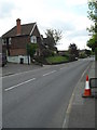
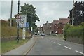
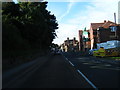
Station Road at the junction of Dawtrey Road
Image: © David Howard
Taken: 3 Aug 2015
0.15 miles
7
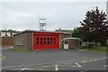
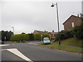
Petworth Fire Station
Petworth Fire Station, Station Road, Petworth, West Sussex
Image: © Kevin Hale
Taken: 6 May 2007
0.23 miles