IMAGES TAKEN NEAR TO
The Drive, Beech Grove, GUILDFORD, GU2 7UY
Introduction
This page details the photographs taken nearby to The Drive, Beech Grove, GU2 7UY by members of the Geograph project.
The Geograph project started in 2005 with the aim of publishing, organising and preserving representative images for every square kilometre of Great Britain, Ireland and the Isle of Man.

There are currently over 7.5m images from over14,400 individuals and you can help contribute to the project by visiting https://www.geograph.org.uk
Image Map
Images are licensed for reuse under creativecommons.org/licenses/by-sa/2.0
Notes
- Clicking on the map will re-center to the selected point.
- The higher the marker number, the further away the image location is from the centre of the postcode.
Image Listing (112 Images Found)
Images are licensed for reuse under creativecommons.org/licenses/by-sa/2.0
Image
Details
Distance
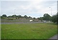
1
Pedestrian route to Rugby Women's World Cup (1)
Image: © Basher Eyre
Taken: 24 Aug 2010
0.01 miles
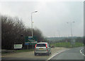
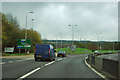
3
Slip road from Stag Hill joining A3 south
Image: © John Firth
Taken: 17 Mar 2012
0.03 miles
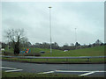
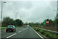
6
A3 - Guildford
The exit for the university and hospitals.
Image: © Robin Webster
Taken: 9 Nov 2011
0.04 miles
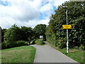
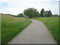
7
View of the A3 from the path to Surrey University
Image: © Basher Eyre
Taken: 24 Aug 2010
0.05 miles
8
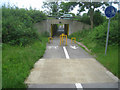
Not enough to slow cyclists
Passing under the A3 link road.
Image: © Fernweh
Taken: 26 Jun 2012
0.05 miles
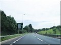
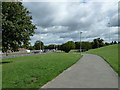
9
A3 - Guildford
The A3 starts to leave Guildford behind.
Image: © Robin Webster
Taken: 9 Nov 2011
0.06 miles