IMAGES TAKEN NEAR TO
Downing Avenue, GUILDFORD, GU2 7SY
Introduction
This page details the photographs taken nearby to Downing Avenue, GU2 7SY by members of the Geograph project.
The Geograph project started in 2005 with the aim of publishing, organising and preserving representative images for every square kilometre of Great Britain, Ireland and the Isle of Man.

There are currently over 7.5m images from over14,400 individuals and you can help contribute to the project by visiting https://www.geograph.org.uk
Image Map
Images are licensed for reuse under creativecommons.org/licenses/by-sa/2.0
Notes
- Clicking on the map will re-center to the selected point.
- The higher the marker number, the further away the image location is from the centre of the postcode.
Image Listing (92 Images Found)
Images are licensed for reuse under creativecommons.org/licenses/by-sa/2.0
Image
Details
Distance
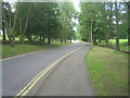
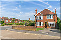
3
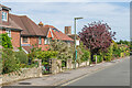
Queen Eleanor's Road
Houses in Queen Eleanor's Road in Onslow Village. The area was developed from 1921 onwards on land mainly owned by Lord Onslow, with this part dating from the c.1930s. The road name refers to Queen Eleanor of Aquitaine, queen to Henry II whose court was in Guildford Castle. In the background is the tower of Guildford Cathedral.
Image: © Ian Capper
Taken: 12 Sep 2022
0.07 miles
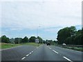
4
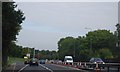
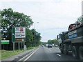
The A3, Guildford bypass
The A3 from the open area near the access road to the Holiday Inn.
Image: © Alan Hunt
Taken: 10 Oct 2012
0.08 miles
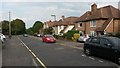
5
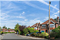
Queen Eleanor's Road
Houses in Queen Eleanor's Road in Onslow Village. The area was developed from 1921 onwards on land mainly owned by Lord Onslow, with this part dating from the c.1930s. The road name refers to Queen Eleanor of Aquitaine, queen to Henry II whose court was in Guildford Castle.
Image: © Ian Capper
Taken: 12 Sep 2022
0.08 miles
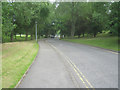
7
East Meads
House in East Meads in Onslow Village by its junction with Queen Eleanor's Road. The area was developed from 1921 onwards on land mainly owned by Lord Onslow, with this part dating from the c.1930s. The 1944 6 inch map marks the road as East Mead, without the final "s". In the background is Guildford Cathedral.
Image: © Ian Capper
Taken: 12 Sep 2022
0.11 miles