IMAGES TAKEN NEAR TO
Litchfield Way, GUILDFORD, GU2 7QH
Introduction
This page details the photographs taken nearby to Litchfield Way, GU2 7QH by members of the Geograph project.
The Geograph project started in 2005 with the aim of publishing, organising and preserving representative images for every square kilometre of Great Britain, Ireland and the Isle of Man.

There are currently over 7.5m images from over14,400 individuals and you can help contribute to the project by visiting https://www.geograph.org.uk
Image Map
Images are licensed for reuse under creativecommons.org/licenses/by-sa/2.0
Notes
- Clicking on the map will re-center to the selected point.
- The higher the marker number, the further away the image location is from the centre of the postcode.
Image Listing (52 Images Found)
Images are licensed for reuse under creativecommons.org/licenses/by-sa/2.0
Image
Details
Distance
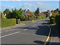
1
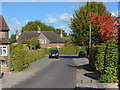
Litchfield Way, Guildford
One of the warren of narrow roads in this suburb of Guildford, built during the 1920s
Image: © Alan Hunt
Taken: 10 Oct 2012
0.01 miles
2
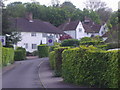
Litchfield Way, Onslow Village
These are the same houses (and road name) as Hampstead Garden Suburb and also Brentham Garden Village in Ealing
Image: © David Howard
Taken: 10 May 2009
0.05 miles
3
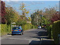
Vicarage gate, Onslow Village
The cul-de-sac leading towards All Saints church in Onslow Village.
Image: © Alan Hunt
Taken: 10 Oct 2012
0.06 miles
4
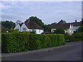
Litchfield Way, Onslow Village
Another area based on the same houses in Hampstead Garden Suburb in North London.
Image: © David Howard
Taken: 10 May 2009
0.07 miles
5
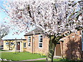
Onslow Village Hall
Spring blossom outside the village hall. The village is a western suburb of Guildford. It takes its name from Lord Onslow - Lord of the Manor at Clandon House.
Image: © Colin Smith
Taken: 22 Mar 2009
0.07 miles
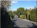
6
Curling Vale, Guildford
A view down Curling Vale in the Onslow Village area of Guildford, with Friars Gate on the right.
Image: © Alan Hunt
Taken: 10 Oct 2012
0.07 miles
7
Wilderness Road, Onslow Village
The view down Wilderness Road in the Onslow Village area of Guildford. This estate was built during the 1920s on the northern slopes of the Hog's Back.
Image: © Alan Hunt
Taken: 10 Oct 2012
0.07 miles
8
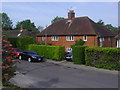
Cottages on Wilderness Road, Onslow Village
Image: © David Howard
Taken: 10 May 2009
0.09 miles
9
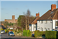
Curling Vale
c.1920/30s housing. In the background is Guildford Cathedral.
Image: © Ian Capper
Taken: 2 Dec 2021
0.10 miles
