IMAGES TAKEN NEAR TO
The Drive, Farnham Road, GUILDFORD, GU2 7QF
Introduction
This page details the photographs taken nearby to The Drive, Farnham Road, GU2 7QF by members of the Geograph project.
The Geograph project started in 2005 with the aim of publishing, organising and preserving representative images for every square kilometre of Great Britain, Ireland and the Isle of Man.

There are currently over 7.5m images from over14,400 individuals and you can help contribute to the project by visiting https://www.geograph.org.uk
Image Map
Images are licensed for reuse under creativecommons.org/licenses/by-sa/2.0
Notes
- Clicking on the map will re-center to the selected point.
- The higher the marker number, the further away the image location is from the centre of the postcode.
Image Listing (55 Images Found)
Images are licensed for reuse under creativecommons.org/licenses/by-sa/2.0
Image
Details
Distance
1
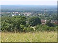
View from Henley Fort
Looking north west from Henley Fort with the Royal Surrey County Hospital the main feature in the middle distance.
Image: © Alan Hunt
Taken: 14 Jul 2013
0.07 miles
2
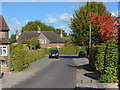
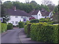
Litchfield Way, Guildford
One of the warren of narrow roads in this suburb of Guildford, built during the 1920s
Image: © Alan Hunt
Taken: 10 Oct 2012
0.09 miles
3
Curling Vale, Guildford
A view down Curling Vale in the Onslow Village area of Guildford, with Friars Gate on the right.
Image: © Alan Hunt
Taken: 10 Oct 2012
0.10 miles
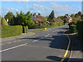
4
Wilderness Road, Onslow Village
The view down Wilderness Road in the Onslow Village area of Guildford. This estate was built during the 1920s on the northern slopes of the Hog's Back.
Image: © Alan Hunt
Taken: 10 Oct 2012
0.10 miles
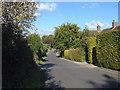
5
Litchfield Way, Onslow Village
These are the same houses (and road name) as Hampstead Garden Suburb and also Brentham Garden Village in Ealing
Image: © David Howard
Taken: 10 May 2009
0.11 miles
6
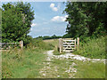
Gateway, Guildown
A gate between two of the fields that run along the northern side of the Hog's Back Ridge with the woods around Henley Fort in the background.
Image: © Alan Hunt
Taken: 14 Jul 2013
0.11 miles
7
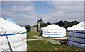
Campsite at Henley Fort
Henley Fort is an outdoor centre on top of the Hogs Back just outside Guildford.
These gers or yurts are part of the accommodation, with a climbing wall in the background.
Image: © Des Blenkinsopp
Taken: 5 Jun 2023
0.12 miles
8
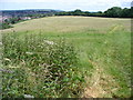
Hogs Back, Eastern End
Looking east to Guildown and Guildford in the Wey Gap. The Hogs Back is a huge whaleback chalky ridge between Farnham and Guildford, the route of the old Harroway.
Image: © Colin Smith
Taken: 22 Jun 2008
0.13 miles
9
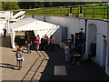
Henley Fort, Guildown
Circular late Victorian fort (1896) on the west side of Guildford. Here it is open to the general public for Heritage Open Day 2010. There were several historic re-enactment groups - including Saxons, WW1 Scottish soldiers, and the WW2 Home Guard - to entertain and interest the visitors.
Image: © Colin Smith
Taken: 12 Sep 2010
0.13 miles
10
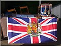
Drum Head Display, Henley Fort
Heritage Open Doors 2010 and display of flag and drum from the Queens Royal West Surrey Regiment.
Image: © Colin Smith
Taken: 12 Sep 2010
0.13 miles