IMAGES TAKEN NEAR TO
Denzil Road, GUILDFORD, GU2 7AT
Introduction
This page details the photographs taken nearby to Denzil Road, GU2 7AT by members of the Geograph project.
The Geograph project started in 2005 with the aim of publishing, organising and preserving representative images for every square kilometre of Great Britain, Ireland and the Isle of Man.

There are currently over 7.5m images from over14,400 individuals and you can help contribute to the project by visiting https://www.geograph.org.uk
Image Map
Images are licensed for reuse under creativecommons.org/licenses/by-sa/2.0
Notes
- Clicking on the map will re-center to the selected point.
- The higher the marker number, the further away the image location is from the centre of the postcode.
Image Listing (796 Images Found)
Images are licensed for reuse under creativecommons.org/licenses/by-sa/2.0
Image
Details
Distance
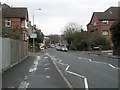
2
Looking from Upperton Road into Denzil Road
Image: © Basher Eyre
Taken: 7 Feb 2009
0.01 miles
4
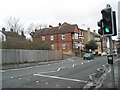
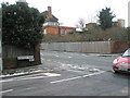
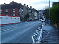
Looking from the pelican crossing on the A31 towards Denzil Road
Image: © Basher Eyre
Taken: 7 Feb 2009
0.01 miles
5
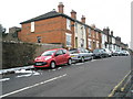
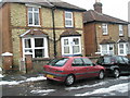
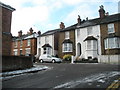
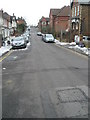
Houses at the southern end of Denzil Road
Image: © Basher Eyre
Taken: 7 Feb 2009
0.01 miles
6
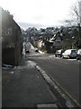
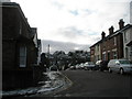
Looking down Denzil Road towards the A31
Image: © Basher Eyre
Taken: 7 Feb 2009
0.01 miles
7
Approaching the crossroads of Wherwell, Denzil and Farnham Roads from the hospital
Image: © Basher Eyre
Taken: 7 Feb 2009
0.01 miles
8
Looking down Farnham Road in Guildford
On the left building works are taking place at the hospital.
Image: © Shazz
Taken: 13 Jan 2014
0.02 miles
9
Looking down Wherwell Road towards the A31
Image: © Basher Eyre
Taken: 7 Feb 2009
0.02 miles