IMAGES TAKEN NEAR TO
The Leys, HASLEMERE, GU27 3JY
Introduction
This page details the photographs taken nearby to The Leys, GU27 3JY by members of the Geograph project.
The Geograph project started in 2005 with the aim of publishing, organising and preserving representative images for every square kilometre of Great Britain, Ireland and the Isle of Man.

There are currently over 7.5m images from over14,400 individuals and you can help contribute to the project by visiting https://www.geograph.org.uk
Image Map (Loading...)


Getting Data...Please wait
Leaflet Map data © OpenStreetMap
Images are licensed for reuse under creativecommons.org/licenses/by-sa/2.0
Notes
- Clicking on the map will re-center to the selected point.
- The higher the marker number, the further away the image location is from the centre of the postcode.
Image Listing (59 Images Found)
Images are licensed for reuse under creativecommons.org/licenses/by-sa/2.0
Image
Details
Distance
1
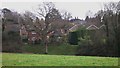
Zig zag steps
The field in front of the houses and steps is a rough area. When I walked by a lot of the undergrowth near the lane had been cleared, presumably to improve access. The steps cut into the bank struck me as picturesque.
Image: © Shazz
Taken: 8 Dec 2009
0.08 miles
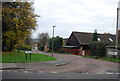
10
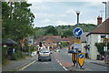
View east along Vann Road nearing its junction with the A286
Image: © Dave Spicer
Taken: 10 Apr 2012
0.11 miles