IMAGES TAKEN NEAR TO
Park Lane, HASLEMERE, GU27 3ED
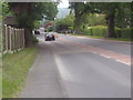
Introduction
This page details the photographs taken nearby to Park Lane, GU27 3ED by members of the Geograph project.
The Geograph project started in 2005 with the aim of publishing, organising and preserving representative images for every square kilometre of Great Britain, Ireland and the Isle of Man.

There are currently over 7.5m images from over14,400 individuals and you can help contribute to the project by visiting https://www.geograph.org.uk
Image Map
Images are licensed for reuse under creativecommons.org/licenses/by-sa/2.0
Notes
- Clicking on the map will re-center to the selected point.
- The higher the marker number, the further away the image location is from the centre of the postcode.
Image Listing (140 Images Found)
Images are licensed for reuse under creativecommons.org/licenses/by-sa/2.0
Image
Details
Distance
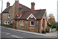
1
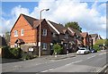
Tavern Court, Fernhurst
Built on the site of the Spread Eagle public house.
http://www.fernhurstsociety.org.uk/archivepix.html
Image: © David960
Taken: 16 Feb 2014
0.07 miles
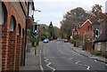
2
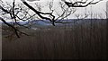
View of Fernhurst
This was taken from the steep path up to Marley Heights. The prominent rise beyond is Bexleyhill.
Image: © Shazz
Taken: 16 Feb 2009
0.07 miles
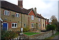
10
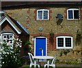
Cottage in Fernhurst
Above the door is a horseshoe and a sort of sun clock which I couldn't read clearly.
Image: © Shazz
Taken: 28 Aug 2012
0.12 miles