IMAGES TAKEN NEAR TO
Hales Field, HASLEMERE, GU27 2JU
Introduction
This page details the photographs taken nearby to Hales Field, GU27 2JU by members of the Geograph project.
The Geograph project started in 2005 with the aim of publishing, organising and preserving representative images for every square kilometre of Great Britain, Ireland and the Isle of Man.

There are currently over 7.5m images from over14,400 individuals and you can help contribute to the project by visiting https://www.geograph.org.uk
Image Map (Loading...)


Getting Data...Please wait
Leaflet Map data © OpenStreetMap
Images are licensed for reuse under creativecommons.org/licenses/by-sa/2.0
Notes
- Clicking on the map will re-center to the selected point.
- The higher the marker number, the further away the image location is from the centre of the postcode.
Image Listing (524 Images Found)
Images are licensed for reuse under creativecommons.org/licenses/by-sa/2.0
Image
Details
Distance
2
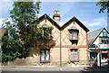
Stone built house, Lower St
Built in 1869.
Image: © N Chadwick
Taken: 11 Jul 2010
0.03 miles
5
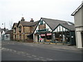
A shop in which my step sons must have shares
Taken at the junction of Shepherd's Hill and Lower Street.
Image: © Basher Eyre
Taken: 1 Jan 2009
0.03 miles
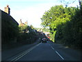
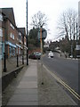
6
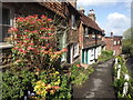
Shepherd's Hill
Raised pavement with a row of picturesque tile-hung cottages on the main road out of Haslemere towards Midhurst.
www.haslemere.com
Image: © Colin Smith
Taken: 7 May 2012
0.03 miles
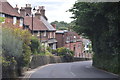
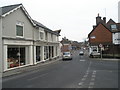
8
Junction of Shepherd's Hill and Lower Street
Image: © Basher Eyre
Taken: 1 Jan 2009
0.04 miles
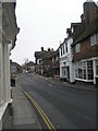
9
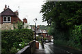
Looking up Shepherd's Hill on New Year's Day, 2009
Image: © Basher Eyre
Taken: 1 Jan 2009
0.04 miles
10
Junction of Lower Street and Shepherd's Hill
Image: © Basher Eyre
Taken: 1 Jan 2009
0.04 miles