IMAGES TAKEN NEAR TO
Grayswood Road, HASLEMERE, GU27 2DL
Introduction
This page details the photographs taken nearby to Grayswood Road, GU27 2DL by members of the Geograph project.
The Geograph project started in 2005 with the aim of publishing, organising and preserving representative images for every square kilometre of Great Britain, Ireland and the Isle of Man.

There are currently over 7.5m images from over14,400 individuals and you can help contribute to the project by visiting https://www.geograph.org.uk
Image Map
Images are licensed for reuse under creativecommons.org/licenses/by-sa/2.0
Notes
- Clicking on the map will re-center to the selected point.
- The higher the marker number, the further away the image location is from the centre of the postcode.
Image Listing (7 Images Found)
Images are licensed for reuse under creativecommons.org/licenses/by-sa/2.0
Image
Details
Distance
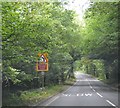
2
Sharp bend on the A286
This is between Grayswood and Brook in Surrey.
Image: © Shazz
Taken: 12 Jun 2009
0.09 miles
3
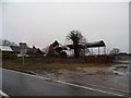
Lower Birtley Farm north of Grayswood
On the A286 just before the railway bridge
Image: © David Howard
Taken: 1 Mar 2015
0.16 miles
4
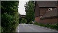
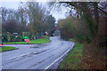
Railway bridge over the A286 north of Grayswood
The railway line is that between Waterloo and Portsmouth.
Image: © Shazz
Taken: 12 Jun 2009
0.22 miles

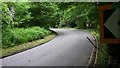
6
Railway Bridge on A286
The entrance to the left is to Haslemere Garden Centre. The bridge height restriction sign advises 15' 3", and its post also bears a bus stop sign.
Image: © Robin Webster
Taken: 11 Feb 2007
0.23 miles
7
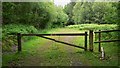
Forestry track off the A286
This track leads from the A286 between Grayswood and Brook.
Image: © Shazz
Taken: 12 Jun 2009
0.24 miles