IMAGES TAKEN NEAR TO
Grayswood Road, HASLEMERE, GU27 2DJ
Introduction
This page details the photographs taken nearby to Grayswood Road, GU27 2DJ by members of the Geograph project.
The Geograph project started in 2005 with the aim of publishing, organising and preserving representative images for every square kilometre of Great Britain, Ireland and the Isle of Man.

There are currently over 7.5m images from over14,400 individuals and you can help contribute to the project by visiting https://www.geograph.org.uk
Image Map (Loading...)


Getting Data...Please wait
Leaflet Map data © OpenStreetMap
Images are licensed for reuse under creativecommons.org/licenses/by-sa/2.0
Notes
- Clicking on the map will re-center to the selected point.
- The higher the marker number, the further away the image location is from the centre of the postcode.
Image Listing (19 Images Found)
Images are licensed for reuse under creativecommons.org/licenses/by-sa/2.0
Image
Details
Distance
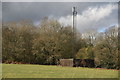
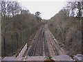
1
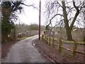
Railway Bridge at Lower Park Farm
Here the footpath crosses the Waterloo to Portsmouth line.
Image: © Shazz
Taken: 4 Apr 2010
0.04 miles
2

A286 by Stroud
Stroud Wood is ahead on the right.
Image: © Robin Webster
Taken: 14 Jul 2012
0.09 miles
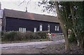
3
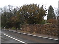
Wall by the Toll House, Grayswood
Looking towards the entrance to Stroud Wood
Image: © David Howard
Taken: 1 Mar 2015
0.09 miles
4
Footpath meets A286
The picture was taken on the footpath from Lower Park Farm. The motorcyclist is on the A286 heading north. Everything beyond is in the next grid square.
Image: © Shazz
Taken: 4 Apr 2010
0.10 miles
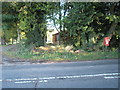
5
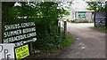
Plant sale on the A286 near Haslemere
Interesting spelling is here to be seen.
Image: © Shazz
Taken: 12 Jun 2009
0.11 miles
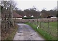
9
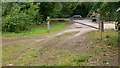
Forestry track leading to A286
This is between Grayswood and Brook. The car in the background is going south on the A286.
Image: © Shazz
Taken: 12 Jun 2009
0.17 miles
10
Railway line near Lower Park Farm
The railway runs between London Waterloo and Portsmouth. This is the view south.
Image: © Shazz
Taken: 4 Apr 2010
0.18 miles