IMAGES TAKEN NEAR TO
Hammer Vale, HASLEMERE, GU27 1QJ
Introduction
This page details the photographs taken nearby to Hammer Vale, GU27 1QJ by members of the Geograph project.
The Geograph project started in 2005 with the aim of publishing, organising and preserving representative images for every square kilometre of Great Britain, Ireland and the Isle of Man.

There are currently over 7.5m images from over14,400 individuals and you can help contribute to the project by visiting https://www.geograph.org.uk
Image Map
Images are licensed for reuse under creativecommons.org/licenses/by-sa/2.0
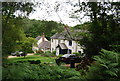
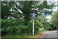
Notes
- Clicking on the map will re-center to the selected point.
- The higher the marker number, the further away the image location is from the centre of the postcode.
Image Listing (54 Images Found)
Images are licensed for reuse under creativecommons.org/licenses/by-sa/2.0
Image
Details
Distance
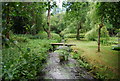
2
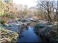
River Wey, Hammer Bottom
Looking upstream.
Image: © Robin Webster
Taken: 20 Jan 2016
0.01 miles
6
River Wey, Hammer Bottom
Here the river forms the boundary between Hampshire (left) and West Sussex (right).
Image: © N Chadwick
Taken: 11 Jul 2010
0.03 miles
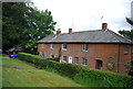
7
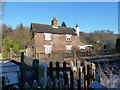
Former crossing keeper's cottage, Hammer Bottom
The crossing, on the left, is now only a foot crossing.
Image: © Robin Webster
Taken: 20 Jan 2016
0.03 miles
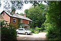
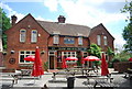
8
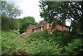
Prince of Wales, Hammer Bottom
A remote rural pub. A Gales House.
Image: © N Chadwick
Taken: 11 Jul 2010
0.04 miles
9
Prince of Wales, Hammer Lane
A remote rural pub built in 1927 on the Hampshire - West Sussex border. A Gales house.
Image: © N Chadwick
Taken: 11 Jul 2010
0.04 miles
10
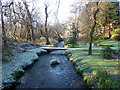
River Wey, Hammer Bottom
Looking downstream.
Image: © Robin Webster
Taken: 20 Jan 2016
0.04 miles