IMAGES TAKEN NEAR TO
Covers Lane, HASLEMERE, GU27 1QF
Introduction
This page details the photographs taken nearby to Covers Lane, GU27 1QF by members of the Geograph project.
The Geograph project started in 2005 with the aim of publishing, organising and preserving representative images for every square kilometre of Great Britain, Ireland and the Isle of Man.

There are currently over 7.5m images from over14,400 individuals and you can help contribute to the project by visiting https://www.geograph.org.uk
Image Map (62 Images)


Getting Data...Please wait
Leaflet Map data © OpenStreetMap
Images are licensed for reuse under creativecommons.org/licenses/by-sa/2.0
Notes
- Clicking on the map will re-center to the selected point.
- The higher the marker number, the further away the image location is from the centre of the postcode.
Image Listing (62 Images Found)
Images are licensed for reuse under creativecommons.org/licenses/by-sa/2.0
Image
Details
Distance
2
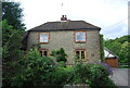
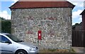
Oak Cottage, Hammer Bottom
A fine stone built property.
Image: © N Chadwick
Taken: 10 Jul 2011
0.03 miles
3
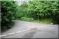
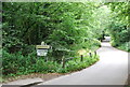
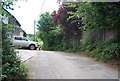
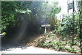
Sandy Lane, Hammer Lane junction
This junction is very close to the border of 3 counties, Hampshire (in this one), Surrey (far side of the road) & west Sussex (off to the right).
Image: © N Chadwick
Taken: 11 Jul 2010
0.04 miles
4
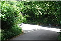
Road sign, Sandy Lane and Hammer Lane junction
Image: © N Chadwick
Taken: 11 Jul 2010
0.04 miles