IMAGES TAKEN NEAR TO
Hindhead Road, HASLEMERE, GU27 1LP
Introduction
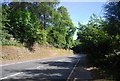
This page details the photographs taken nearby to Hindhead Road, GU27 1LP by members of the Geograph project.
The Geograph project started in 2005 with the aim of publishing, organising and preserving representative images for every square kilometre of Great Britain, Ireland and the Isle of Man.

There are currently over 7.5m images from over14,400 individuals and you can help contribute to the project by visiting https://www.geograph.org.uk
Image Map (Loading...)


Getting Data...Please wait
Leaflet Map data © OpenStreetMap
Images are licensed for reuse under creativecommons.org/licenses/by-sa/2.0
Notes
- Clicking on the map will re-center to the selected point.
- The higher the marker number, the further away the image location is from the centre of the postcode.
Image Listing (21 Images Found)
Images are licensed for reuse under creativecommons.org/licenses/by-sa/2.0
Image
Details
Distance

6
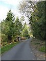
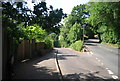
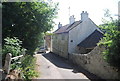
2020 vision: Day 103
Mid section of Buffbeards Lane
Temperature, 18C
BBC Radio Four News Bulletin, 18:00- on the day British deaths rise above 10,000 Boris Johnson leaves hospital he pays an emotional tribute to the NHS
Image: © Basher Eyre
Taken: 12 Apr 2020
0.13 miles