IMAGES TAKEN NEAR TO
Lower Hanger, HASLEMERE, GU27 1FF
Introduction
This page details the photographs taken nearby to Lower Hanger, GU27 1FF by members of the Geograph project.
The Geograph project started in 2005 with the aim of publishing, organising and preserving representative images for every square kilometre of Great Britain, Ireland and the Isle of Man.

There are currently over 7.5m images from over14,400 individuals and you can help contribute to the project by visiting https://www.geograph.org.uk
Image Map (Loading...)


Getting Data...Please wait
Leaflet Map data © OpenStreetMap
Images are licensed for reuse under creativecommons.org/licenses/by-sa/2.0
Notes
- Clicking on the map will re-center to the selected point.
- The higher the marker number, the further away the image location is from the centre of the postcode.
Image Listing (48 Images Found)
Images are licensed for reuse under creativecommons.org/licenses/by-sa/2.0
Image
Details
Distance
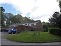
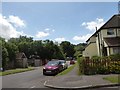
5
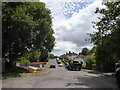
Junction of sunvale Close and Sunvale Avenue
Image: © Basher Eyre
Taken: 21 Jun 2020
0.15 miles
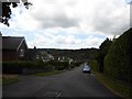
6
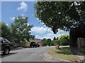
Looking from Sunvale Avenue towards Sunvale Close
Image: © Basher Eyre
Taken: 21 Jun 2020
0.15 miles
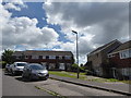
7
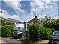
Road and path junction in Pitfold Avenue
Image: © Basher Eyre
Taken: 21 Jun 2020
0.15 miles
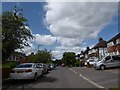
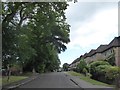
9
Looking from Sunvale Avenue into Oak Tree Lane
Image: © Basher Eyre
Taken: 21 Jun 2020
0.17 miles
10
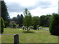
Shottermill Cemetery on the longest day (e)
Image: © Basher Eyre
Taken: 21 Jun 2020
0.17 miles