IMAGES TAKEN NEAR TO
Grove Road, HINDHEAD, GU26 6QP
Introduction
This page details the photographs taken nearby to Grove Road, GU26 6QP by members of the Geograph project.
The Geograph project started in 2005 with the aim of publishing, organising and preserving representative images for every square kilometre of Great Britain, Ireland and the Isle of Man.

There are currently over 7.5m images from over14,400 individuals and you can help contribute to the project by visiting https://www.geograph.org.uk
Image Map (Loading...)


Getting Data...Please wait
Leaflet Map data © OpenStreetMap
Images are licensed for reuse under creativecommons.org/licenses/by-sa/2.0
Notes
- Clicking on the map will re-center to the selected point.
- The higher the marker number, the further away the image location is from the centre of the postcode.
Image Listing (59 Images Found)
Images are licensed for reuse under creativecommons.org/licenses/by-sa/2.0
Image
Details
Distance
1
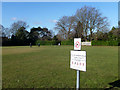
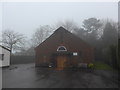
Beaconhill Recreation Ground
Owned and managed by Waverley Borough Council, according to the sign.
Image: © Robin Webster
Taken: 18 Feb 2015
0.06 miles
3
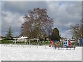
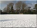
Beacon Hill Playground
Playground in the corner of the recreation ground, not very popular in the snow.
Image: © Ben Gamble
Taken: 7 Feb 2009
0.08 miles
5

Statue outside Anselm's RC Church, Beacon Hill
Image: © Basher Eyre
Taken: 3 Jan 2015
0.09 miles
6
St Anselm's RC Church, Beacon Hill: early January 2015
Image: © Basher Eyre
Taken: 3 Jan 2015
0.09 miles
7
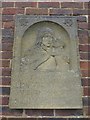
Memorial on an outside wall, St Anselm's RC Church, Beacon Hill
Image: © Basher Eyre
Taken: 3 Jan 2015
0.09 miles
8
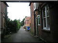
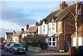
Looking along Hampton Terrace towards the car park
Image: © Basher Eyre
Taken: 20 Aug 2008
0.10 miles
10
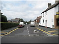
Junction of Hill Road and Beacon Hill Road
Image: © Basher Eyre
Taken: 20 Aug 2008
0.11 miles