IMAGES TAKEN NEAR TO
Wood Road, HINDHEAD, GU26 6PW
Introduction
This page details the photographs taken nearby to Wood Road, GU26 6PW by members of the Geograph project.
The Geograph project started in 2005 with the aim of publishing, organising and preserving representative images for every square kilometre of Great Britain, Ireland and the Isle of Man.

There are currently over 7.5m images from over14,400 individuals and you can help contribute to the project by visiting https://www.geograph.org.uk
Image Map (Loading...)


Getting Data...Please wait
Leaflet Map data © OpenStreetMap
Images are licensed for reuse under creativecommons.org/licenses/by-sa/2.0
Notes
- Clicking on the map will re-center to the selected point.
- The higher the marker number, the further away the image location is from the centre of the postcode.
Image Listing (52 Images Found)
Images are licensed for reuse under creativecommons.org/licenses/by-sa/2.0
Image
Details
Distance
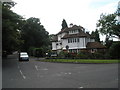
1
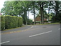
Junction of Wood Road and Downview Close
Image: © Basher Eyre
Taken: 20 Aug 2008
0.01 miles
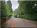
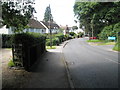
4
Bus stop at the eastern end of Wood Road
Image: © Basher Eyre
Taken: 20 Aug 2008
0.06 miles

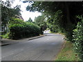
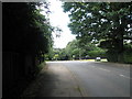
7
Tilford Road approaching turning for Marchants Hill
Image: © Basher Eyre
Taken: 20 Aug 2008
0.06 miles
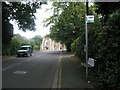
9
Looking towards the junction of Wood and Tilford Roads
To the right is a blue sign signalling St Alban's, Hindhead.
Image: © Basher Eyre
Taken: 20 Aug 2008
0.07 miles
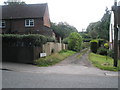
10
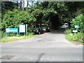
Entrance to Marchant's Hill
Just up the track is a delightful cricket ground.
Image: © Basher Eyre
Taken: 20 Aug 2008
0.08 miles