IMAGES TAKEN NEAR TO
Stoney Bottom, HINDHEAD, GU26 6EH
Introduction
This page details the photographs taken nearby to Stoney Bottom, GU26 6EH by members of the Geograph project.
The Geograph project started in 2005 with the aim of publishing, organising and preserving representative images for every square kilometre of Great Britain, Ireland and the Isle of Man.

There are currently over 7.5m images from over14,400 individuals and you can help contribute to the project by visiting https://www.geograph.org.uk
Image Map
Images are licensed for reuse under creativecommons.org/licenses/by-sa/2.0
Notes
- Clicking on the map will re-center to the selected point.
- The higher the marker number, the further away the image location is from the centre of the postcode.
Image Listing (127 Images Found)
Images are licensed for reuse under creativecommons.org/licenses/by-sa/2.0
Image
Details
Distance
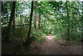
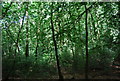
4
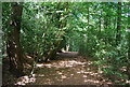
Path to Stoney Bottom
There are small areas of woodland within the spread out housing of Grayshott. Being on sandy soil the predominant species are conifers.
Image: © Graham Horn
Taken: 14 Jan 2012
0.08 miles
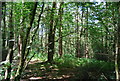
8
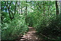
Footpath to Grayshott near Stoney Bottom
Image: © N Chadwick
Taken: 11 Jul 2010
0.12 miles
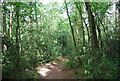
10
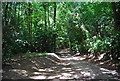
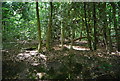
Stoney Bottom
A woodland byway near Grayshott.
Image: © N Chadwick
Taken: 11 Jul 2010
0.15 miles