IMAGES TAKEN NEAR TO
The Paddock, HINDHEAD, GU26 6EF
Introduction
This page details the photographs taken nearby to The Paddock, GU26 6EF by members of the Geograph project.
The Geograph project started in 2005 with the aim of publishing, organising and preserving representative images for every square kilometre of Great Britain, Ireland and the Isle of Man.

There are currently over 7.5m images from over14,400 individuals and you can help contribute to the project by visiting https://www.geograph.org.uk
Image Map
Images are licensed for reuse under creativecommons.org/licenses/by-sa/2.0
Notes
- Clicking on the map will re-center to the selected point.
- The higher the marker number, the further away the image location is from the centre of the postcode.
Image Listing (128 Images Found)
Images are licensed for reuse under creativecommons.org/licenses/by-sa/2.0
Image
Details
Distance
1
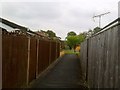
Waggoners Estate, Grayshott
The Waggoners Way end of the footpath from Wheelwrights Lane.
Image: © David960
Taken: 19 May 2013
0.02 miles
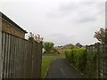
2

Waggoners Estate, Grayshott
The footpath between Wheelwrights Lane and Waggoners Way.
Image: © David960
Taken: 19 May 2013
0.02 miles
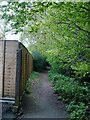
3
Waggoners Estate, Grayshott
Looking back to Waggoners Way from the footpath leading to Whitmore Vale.
Image: © David960
Taken: 19 May 2013
0.03 miles
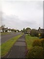
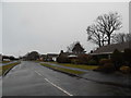
9
Halters End at the junction of Headley Road
Image: © David Howard
Taken: 1 Mar 2015
0.13 miles
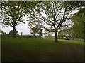
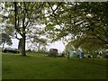
10

Grayshott Recreation Ground
Cycling in progress here, elsewhere a family was playing cricket.
Image: © Shazz
Taken: 20 Feb 2009
0.16 miles