IMAGES TAKEN NEAR TO
Harpesford Avenue, VIRGINIA WATER, GU25 4RA
Introduction
This page details the photographs taken nearby to Harpesford Avenue, GU25 4RA by members of the Geograph project.
The Geograph project started in 2005 with the aim of publishing, organising and preserving representative images for every square kilometre of Great Britain, Ireland and the Isle of Man.

There are currently over 7.5m images from over14,400 individuals and you can help contribute to the project by visiting https://www.geograph.org.uk
Image Map
Images are licensed for reuse under creativecommons.org/licenses/by-sa/2.0
Notes
- Clicking on the map will re-center to the selected point.
- The higher the marker number, the further away the image location is from the centre of the postcode.
Image Listing (11 Images Found)
Images are licensed for reuse under creativecommons.org/licenses/by-sa/2.0
Image
Details
Distance
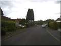
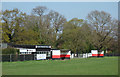
3
Harpesford Avenue at the junction of Crown Road
Image: © David Howard
Taken: 31 May 2015
0.10 miles
6
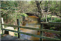
Bridge over The Bourne
The water is an orange colour from the iron rich soil around here. The stream flows through a strip of woodland with good footpath access, although the general wetness of the area has meant several bridges and causeways have been needed.
Image: © Des Blenkinsopp
Taken: 6 Apr 2017
0.17 miles
7
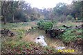
The Bourne, Virginia Water
Recent clearance of trees has opened up this scene of The Bourne in the woodland between Virginia Water and Trumps Green. This view is taken looking westwards and upstream.
Image: © Nigel Cox
Taken: 9 Nov 2004
0.18 miles
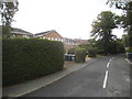
8
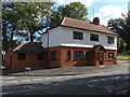
The Stag and Hounds
The Stag and Hounds public house on the corner of Crown Road and Wellington Avenue. This inn closed down some months after this photograph was taken and converted into a private dwelling. See photograph Image for the same view in 2012.
Image: © Alan Hunt
Taken: 3 May 2010
0.18 miles
9
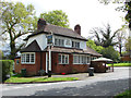
Converted public house
This newly converted property used to be the Stag and Hounds public house until 2010. See photograph Image for the original public house.
Image: © Alan Hunt
Taken: 19 Sep 2012
0.19 miles