IMAGES TAKEN NEAR TO
Fairway, VIRGINIA WATER, GU25 4QZ
Introduction
This page details the photographs taken nearby to Fairway, GU25 4QZ by members of the Geograph project.
The Geograph project started in 2005 with the aim of publishing, organising and preserving representative images for every square kilometre of Great Britain, Ireland and the Isle of Man.

There are currently over 7.5m images from over14,400 individuals and you can help contribute to the project by visiting https://www.geograph.org.uk
Image Map
Images are licensed for reuse under creativecommons.org/licenses/by-sa/2.0
Notes
- Clicking on the map will re-center to the selected point.
- The higher the marker number, the further away the image location is from the centre of the postcode.
Image Listing (22 Images Found)
Images are licensed for reuse under creativecommons.org/licenses/by-sa/2.0
Image
Details
Distance
2
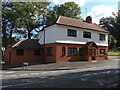
Converted public house
This newly converted property used to be the Stag and Hounds public house until 2010. See photograph Image for the original public house.
Image: © Alan Hunt
Taken: 19 Sep 2012
0.11 miles
3
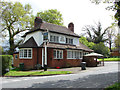
The Stag and Hounds
The Stag and Hounds public house on the corner of Crown Road and Wellington Avenue. This inn closed down some months after this photograph was taken and converted into a private dwelling. See photograph Image for the same view in 2012.
Image: © Alan Hunt
Taken: 3 May 2010
0.12 miles
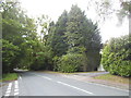
5
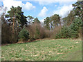
Knowle Hill
Scrub on the edge of the Wentworth Golf Course. If your ball ends up here then just forget it!!
Image: © Alan Hunt
Taken: 5 Apr 2010
0.15 miles
6
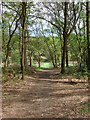
Wentworth Estate
Footpath through the woods from Wentworth Golf Course to Wellington Avenue.
Image: © Alan Hunt
Taken: 3 May 2010
0.15 miles
8
View from Knowle Hill
The view northeast from Knowle Hill with the houses along Wellington Avenue appearing through the trees.
Image: © Alan Hunt
Taken: 28 Nov 2015
0.19 miles
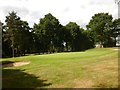
9
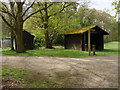
Wentworth Golf Course
Shelter near one of the far-flung greens of the East Course
Image: © Alan Hunt
Taken: 3 May 2010
0.19 miles
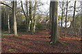
10
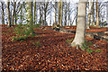
Knowle Hill
A beech covered rise by the junction of Wellington Avenue with Trumps Green Road. This area is part of the Wentworth Estate.
Image: © Alan Hunt
Taken: 28 Nov 2015
0.22 miles