IMAGES TAKEN NEAR TO
Waterfall Close, VIRGINIA WATER, GU25 4QD
Introduction
This page details the photographs taken nearby to Waterfall Close, GU25 4QD by members of the Geograph project.
The Geograph project started in 2005 with the aim of publishing, organising and preserving representative images for every square kilometre of Great Britain, Ireland and the Isle of Man.

There are currently over 7.5m images from over14,400 individuals and you can help contribute to the project by visiting https://www.geograph.org.uk
Image Map
Images are licensed for reuse under creativecommons.org/licenses/by-sa/2.0
Notes
- Clicking on the map will re-center to the selected point.
- The higher the marker number, the further away the image location is from the centre of the postcode.
Image Listing (76 Images Found)
Images are licensed for reuse under creativecommons.org/licenses/by-sa/2.0
Image
Details
Distance
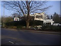
3
The Piccolino, Virginia Water
It has now been shared with Laithwaites Wine since the first time I took it.
Image: © David Howard
Taken: 22 Mar 2015
0.06 miles
5
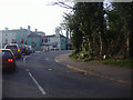
B389 at junction of A30, Virginia Water
Image: © David Howard
Taken: 20 Mar 2011
0.07 miles
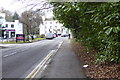
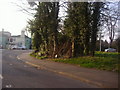
7
The A30 at the junction of Christchurch Road
Image: © David Howard
Taken: 22 Mar 2015
0.09 miles
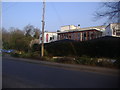
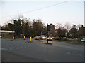
8
Looking across the A30 to the Wheatsheaf Hotel
See also http://www.geograph.org.uk/photo/3933456.
Image: © Shazz
Taken: 21 Feb 2015
0.09 miles
9
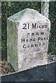
Old Milestone by the A30, Cascade Bridge, Egham
Reused Hounslow limestone square by the A30, in parish of Egham (Runnymede District), North East corner of bridge over Virginia Water, South of Wheatsheaf PH, between tarmac footpath and chain link fence behind crash barrier over bridge. Re-located from nearer the centre of the bridge.
Inscription reads:-
21 MILES
FROM
HYDE PARK
CORNER
Surveyed
Milestone Society National ID: SY_le21
Image: © Milestone Society
Taken: Unknown
0.10 miles
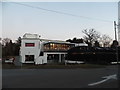
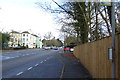
10
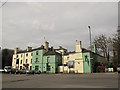
The Wheatsheaf at Virginia Water
The location of this large pub at a junction on a historic main road suggests it would originally have been a coaching inn.
Image: © Stephen Craven
Taken: 12 Apr 2014
0.10 miles