IMAGES TAKEN NEAR TO
Woodlands Road West, VIRGINIA WATER, GU25 4PN
Introduction
This page details the photographs taken nearby to Woodlands Road West, GU25 4PN by members of the Geograph project.
The Geograph project started in 2005 with the aim of publishing, organising and preserving representative images for every square kilometre of Great Britain, Ireland and the Isle of Man.

There are currently over 7.5m images from over14,400 individuals and you can help contribute to the project by visiting https://www.geograph.org.uk
Image Map
Images are licensed for reuse under creativecommons.org/licenses/by-sa/2.0
Notes
- Clicking on the map will re-center to the selected point.
- The higher the marker number, the further away the image location is from the centre of the postcode.
Image Listing (33 Images Found)
Images are licensed for reuse under creativecommons.org/licenses/by-sa/2.0
Image
Details
Distance
1
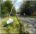
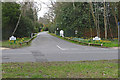
Woodlands Road East
The signage and white gates show this is part of the Wentworth Estate which has private roads all over this area.
I think the gates may be to do with that Private Road thing where if you shut them one day a year you can prove it's not a thoroughfare.
Image: © Des Blenkinsopp
Taken: 21 Mar 2017
0.12 miles
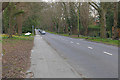
2
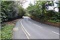
Christchurch Road B389
This public road acts as a spine road of the exclusive Wentworth Estate, a 700ha private estate that was developed from the 1920s to 1960s - see the official website http://www.wentworthestate.org.uk
The road is busy with fast-moving traffic, so the north side footpath (right hand side in this photo) is shared use for cyclists and pedestrians.
Image: © Stephen Craven
Taken: 12 Apr 2014
0.14 miles
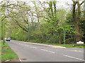
3
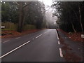
Christchurch Road, Virginia Water
The stretch of Christchurch Road east of the Callow Hill junction. Most of the roads off this stretch are part of the Wentworth Estate.
Image: © Alan Hunt
Taken: 31 Mar 2016
0.14 miles
4
Walkway along Christchurch Road
The walkway along Christchurch Road heading towards Virginia Water village centre.
Image: © Alan Hunt
Taken: 31 Mar 2016
0.14 miles
6
Woodlands Road East, Virginia Water
The junction of Woodlands Road East with Christchurch Road. Woodlands Road is part of the Wentworth Estate.
Image: © Alan Hunt
Taken: 31 Mar 2016
0.15 miles
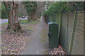
7
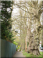
Tree in the path adjacent to Christchurch Road
A row of mature trees grows between the road Image and the footpath. But one tree grows out of the middle of the footpath which has been diverted round it.
Image: © Stephen Craven
Taken: 12 Apr 2014
0.16 miles
9
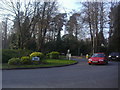
Roundabout on Christchurch Road, Virginia Water
Image: © David Howard
Taken: 20 Mar 2011
0.18 miles
10
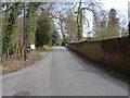
Hollow Lane, Virginia Water
The access road and bridleway that runs from Callow Hill towards Stroude Farm.
Image: © Alan Hunt
Taken: 5 Apr 2010
0.18 miles