IMAGES TAKEN NEAR TO
Portnall Rise, VIRGINIA WATER, GU25 4JZ
Introduction
This page details the photographs taken nearby to Portnall Rise, GU25 4JZ by members of the Geograph project.
The Geograph project started in 2005 with the aim of publishing, organising and preserving representative images for every square kilometre of Great Britain, Ireland and the Isle of Man.

There are currently over 7.5m images from over14,400 individuals and you can help contribute to the project by visiting https://www.geograph.org.uk
Image Map
Images are licensed for reuse under creativecommons.org/licenses/by-sa/2.0
Notes
- Clicking on the map will re-center to the selected point.
- The higher the marker number, the further away the image location is from the centre of the postcode.
Image Listing (15 Images Found)
Images are licensed for reuse under creativecommons.org/licenses/by-sa/2.0
Image
Details
Distance
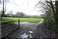
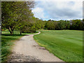
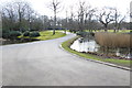
3
Wentworth Golf Course
Road leading from the clubhouse to the West Course
Image: © Alan Hunt
Taken: 3 May 2010
0.18 miles
4
Looking west to large building
See also http://www.geograph.org.uk/photo/1837971for different view from 2010.
Image: © Shazz
Taken: 21 Feb 2015
0.20 miles
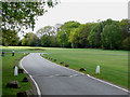
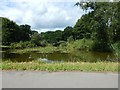
5
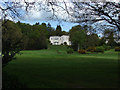
Wentworth Golf Course
View of the Dormy House from near the two lakes off Portnall Rise
Image: © Alan Hunt
Taken: 3 May 2010
0.21 miles
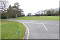
6
Wentworth Golf Course
The track running back towards the clubhouse area from the west course.
Image: © Alan Hunt
Taken: 3 May 2010
0.21 miles
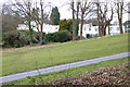
7
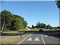
Wentworth Golf Club
Looking towards the club house on the left
Image: © David Howard
Taken: 7 Jun 2015
0.22 miles
8
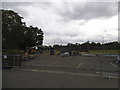
Car Park at Wentworth Golf Club
They appear to be removing all the barriers from last week's English Open
Image: © David Howard
Taken: 31 May 2015
0.23 miles
10
Wentworth Golf Course - Lake near The Dormy House
Image: © James Emmans
Taken: 21 Jul 2017
0.23 miles