IMAGES TAKEN NEAR TO
East Drive, VIRGINIA WATER, GU25 4JY
Introduction
This page details the photographs taken nearby to East Drive, GU25 4JY by members of the Geograph project.
The Geograph project started in 2005 with the aim of publishing, organising and preserving representative images for every square kilometre of Great Britain, Ireland and the Isle of Man.

There are currently over 7.5m images from over14,400 individuals and you can help contribute to the project by visiting https://www.geograph.org.uk
Image Map
Images are licensed for reuse under creativecommons.org/licenses/by-sa/2.0
Notes
- Clicking on the map will re-center to the selected point.
- The higher the marker number, the further away the image location is from the centre of the postcode.
Image Listing (14 Images Found)
Images are licensed for reuse under creativecommons.org/licenses/by-sa/2.0
Image
Details
Distance
1
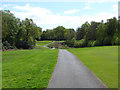
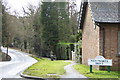
Wentworth Golf Course
Track leading to one of the tees from Wentworth Drive
Image: © Alan Hunt
Taken: 3 May 2010
0.10 miles
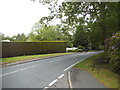
4
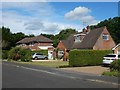
Harpesford Avenue, Virginia Water
A residential road.
Image: © Robin Webster
Taken: 26 Jun 2016
0.16 miles
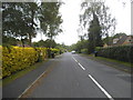
6
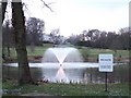
Bend on Wellington Avenue
The watercourse at the bottom is The Bourne.
Image: © Shazz
Taken: 21 Feb 2015
0.18 miles
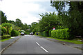
10
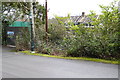
Wentworth Avenue
Going through the golf club
Image: © David Howard
Taken: 31 May 2015
0.21 miles