IMAGES TAKEN NEAR TO
Bridge Lane, VIRGINIA WATER, GU25 4ER
Introduction
This page details the photographs taken nearby to Bridge Lane, GU25 4ER by members of the Geograph project.
The Geograph project started in 2005 with the aim of publishing, organising and preserving representative images for every square kilometre of Great Britain, Ireland and the Isle of Man.

There are currently over 7.5m images from over14,400 individuals and you can help contribute to the project by visiting https://www.geograph.org.uk
Image Map
Images are licensed for reuse under creativecommons.org/licenses/by-sa/2.0
Notes
- Clicking on the map will re-center to the selected point.
- The higher the marker number, the further away the image location is from the centre of the postcode.
Image Listing (36 Images Found)
Images are licensed for reuse under creativecommons.org/licenses/by-sa/2.0
Image
Details
Distance
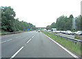
1
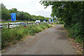
Disused road beside M3
A section of disused road on the south side of the M3 near junction 2.
Image: © Alan Hunt
Taken: 25 Jun 2015
0.06 miles
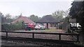
2
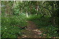
Bourne Copse near Lyne
A small area of woodland to the south of the M3 near junction 2.
Image: © Alan Hunt
Taken: 25 Jun 2015
0.07 miles
4
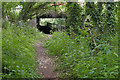
Culvert under the M3
The culvert under the M3 west of junction 2 allowing passage for the footpath and the Bourne stream.
Image: © Alan Hunt
Taken: 25 Jun 2015
0.08 miles
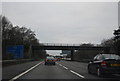
5

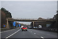
Borough of Runnymede : M3 Motorway
The M3 Motorway between Junction 2 (Thorpe Interchange) and Junction 3 (Bagshot Interchange).
Image: © Lewis Clarke
Taken: 25 Mar 2018
0.09 miles
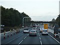
10

M3 westbound
Now finished here as 'managed motorway', widened to four lanes each way, but with no hard shoulder.
Image: © Robin Webster
Taken: 23 Nov 2017
0.10 miles