IMAGES TAKEN NEAR TO
Bridge Lane, VIRGINIA WATER, GU25 4ED
Introduction
This page details the photographs taken nearby to Bridge Lane, GU25 4ED by members of the Geograph project.
The Geograph project started in 2005 with the aim of publishing, organising and preserving representative images for every square kilometre of Great Britain, Ireland and the Isle of Man.

There are currently over 7.5m images from over14,400 individuals and you can help contribute to the project by visiting https://www.geograph.org.uk
Image Map
Images are licensed for reuse under creativecommons.org/licenses/by-sa/2.0
Notes
- Clicking on the map will re-center to the selected point.
- The higher the marker number, the further away the image location is from the centre of the postcode.
Image Listing (10 Images Found)
Images are licensed for reuse under creativecommons.org/licenses/by-sa/2.0
Image
Details
Distance
1
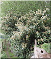
Laurel in flower, footpath near Lyne
Laurel seems to have particularly luxuriant flowers this spring. This bush is by the footpath between Trumps Farm and Lyne Place Manor.
Image: © David Hawgood
Taken: 7 May 2006
0.08 miles
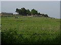
2
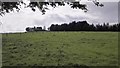
Fields near Trumps Farm
Open countryside.
Image: © James Emmans
Taken: 11 May 2016
0.10 miles
3
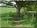
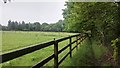
Footpath, Fairview farm
The footpath that runs from Chertsey Common across Fairview Farm towards Lyne Place.
Image: © Alan Hunt
Taken: 21 May 2012
0.13 miles
5
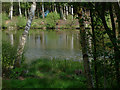
Lake, Lyne Place
The private fishing lake from the footpath that runs across Fairview Farm.
Image: © Alan Hunt
Taken: 21 May 2012
0.14 miles
6
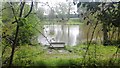
Lyne Lake - Fishing
Small dedicated and well hidden fishing lake on Lyne Place Manor grounds. The Manor has been converted into luxury accommodation.
Info : http://allaboutangling.net/?page_id=478
Image: © James Emmans
Taken: 11 May 2016
0.18 miles
7
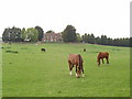
Horses grazing at Trumps Farm
Taken from the footpath which runs beside the fishing lake of Lyne Place Manor
Image: © David Hawgood
Taken: 7 May 2006
0.20 miles
8

Footpath with cow parsley, Lyne
The short stretch of public footpath (not shown on the OS map) runs from Lyne Place Manor gates to Lyne Crossing Road, just east of the M3. There are a number of similar white Umbellifers as wild flowers, Cow Parsley (Anthriscus sylvestris) is the most common.
Image: © David Hawgood
Taken: 7 May 2006
0.21 miles
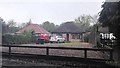
9
Fairview Farm
A view of Fairview farm from the edge of Bluebell Wood.
Image: © Alan Hunt
Taken: 21 May 2012
0.22 miles