IMAGES TAKEN NEAR TO
Trumpsgreen Road, VIRGINIA WATER, GU25 4DZ
Introduction
This page details the photographs taken nearby to Trumpsgreen Road, GU25 4DZ by members of the Geograph project.
The Geograph project started in 2005 with the aim of publishing, organising and preserving representative images for every square kilometre of Great Britain, Ireland and the Isle of Man.

There are currently over 7.5m images from over14,400 individuals and you can help contribute to the project by visiting https://www.geograph.org.uk
Image Map
Images are licensed for reuse under creativecommons.org/licenses/by-sa/2.0
Notes
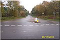
- Clicking on the map will re-center to the selected point.
- The higher the marker number, the further away the image location is from the centre of the postcode.
Image Listing (38 Images Found)
Images are licensed for reuse under creativecommons.org/licenses/by-sa/2.0
Image
Details
Distance
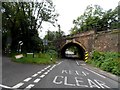
1
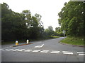
Bridge Lane at the junction of Trumpsgreen Road
Image: © David Howard
Taken: 31 May 2015
0.04 miles
2
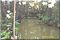
The Bourne, Virginia Water
The Bourne flowing through dense woodland just downstream of Waterloo Bridge on Trumpsgreen Road, viewed looking eastwards and downstream.
Image: © Nigel Cox
Taken: 9 Nov 2004
0.05 miles
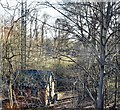
5
Railway bridge, Virginia Water
The railway is the Chertsey Branch Line which opened in 1848. It connects the Waterloo-Reading line with the South Western Main Line
Image: © Bikeboy
Taken: 13 Jul 2014
0.10 miles
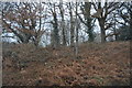
6
Trumps Green, Bridge Lane
Viewed looking south-eastwards from its junction with Trumpsgreen Road, Bridge Lane is intriguingly not shown at all on the OS 1940s map.
Image: © Nigel Cox
Taken: 9 Nov 2004
0.15 miles
7
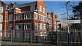
Flats at Virginia Water
Newly built flats beside the station. I'm not a big fan of modern buildings, but I think the bricks, used here, look particularly attractive.
Image: © Peter Trimming
Taken: 14 Feb 2009
0.16 miles
9
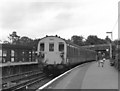
Virginia Water station, Surrey
With a 2-SAP electric unit.
Image: © Dr Neil Clifton
Taken: 18 Jul 1979
0.17 miles
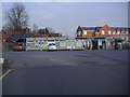
10
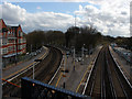
Virginia Water Station
A view of the station from the road bridge on Christchurch Road. This is where the line splits for Chertsey (left) and Sunningdale (right).
Image: © Alan Hunt
Taken: 5 Apr 2010
0.17 miles