IMAGES TAKEN NEAR TO
Sandhills Lane, VIRGINIA WATER, GU25 4DS
Introduction
This page details the photographs taken nearby to Sandhills Lane, GU25 4DS by members of the Geograph project.
The Geograph project started in 2005 with the aim of publishing, organising and preserving representative images for every square kilometre of Great Britain, Ireland and the Isle of Man.

There are currently over 7.5m images from over14,400 individuals and you can help contribute to the project by visiting https://www.geograph.org.uk
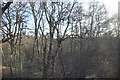
Image Map
Images are licensed for reuse under creativecommons.org/licenses/by-sa/2.0
Notes
- Clicking on the map will re-center to the selected point.
- The higher the marker number, the further away the image location is from the centre of the postcode.
Image Listing (19 Images Found)
Images are licensed for reuse under creativecommons.org/licenses/by-sa/2.0
Image
Details
Distance
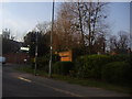
1
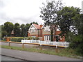
Houses on The Gardens by Sandhills Road
The houses and access have been recently renovated from derelict a few years earlier.
Image: © David Howard
Taken: 27 Jul 2015
0.02 miles
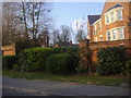
2
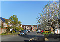
The Orchard, Virginia Water
Featuring a cherry tree, which seems appropriate.
New housing near Virginia Water station.
Image: © Des Blenkinsopp
Taken: 6 Apr 2017
0.07 miles
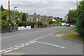
3
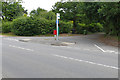
Trumps Mill Lane
The junction of Trumps Mill Lane, an access road to Trumps Mill, with Sandhills Lane near Virginia Water.
Image: © Alan Hunt
Taken: 25 Jun 2015
0.07 miles
4
Flats on Sandhills Lane Virginia Water
Image: © David Howard
Taken: 20 Mar 2011
0.09 miles
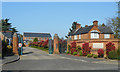
5
Houses along Sandhills Lane
Houses along the north side of Sandhills Lane from the junction of Trumps Mill Lane.
Image: © Alan Hunt
Taken: 25 Jun 2015
0.10 miles
6
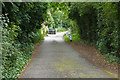
Trumps Mill Lane
Looking south along Trumps Mill Lane, an access road off Sandhills Lane near Virginia Water.
Image: © Alan Hunt
Taken: 25 Jun 2015
0.11 miles
7
St Ann's Park, Virginia Water
Another gated settlement near Virginia Water station.
Image: © Des Blenkinsopp
Taken: 6 Apr 2017
0.12 miles
8
Sandhills Lane Virginia Water
At junction of Stroude Road
Image: © David Howard
Taken: 20 Mar 2011
0.12 miles
9
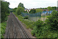
View towards Virginia Water
Looking west along the railway from Trumps Mill Bridge with St Anne's Heath school on the right.
Image: © Alan Hunt
Taken: 25 Jun 2015
0.13 miles