IMAGES TAKEN NEAR TO
St. Catherines Hill, GUILDFORD, GU2 4EF
Introduction
This page details the photographs taken nearby to St. Catherines Hill, GU2 4EF by members of the Geograph project.
The Geograph project started in 2005 with the aim of publishing, organising and preserving representative images for every square kilometre of Great Britain, Ireland and the Isle of Man.

There are currently over 7.5m images from over14,400 individuals and you can help contribute to the project by visiting https://www.geograph.org.uk
Image Map
Images are licensed for reuse under creativecommons.org/licenses/by-sa/2.0
Notes
- Clicking on the map will re-center to the selected point.
- The higher the marker number, the further away the image location is from the centre of the postcode.
Image Listing (234 Images Found)
Images are licensed for reuse under creativecommons.org/licenses/by-sa/2.0
Image
Details
Distance
1
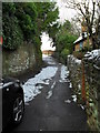
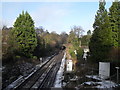
Looking up Ferry Lane towards the railway bridge
Image: © Basher Eyre
Taken: 22 Dec 2009
0.01 miles
2
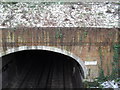
Looking from Ferry Lane Bridge down into St Catherine's Tunnel
Image: © Basher Eyre
Taken: 22 Dec 2009
0.01 miles
4
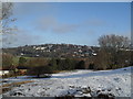
View from the top of St Catherine's Hill
Image: © Basher Eyre
Taken: 22 Dec 2009
0.01 miles
5
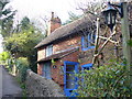
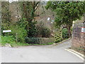
Ferry Cottage
Old brick cottage on Ferry Lane, Guildford. The ferry is long gone and has been replaced by a footbridge over the River Wey.
Image: © Colin Smith
Taken: 20 Apr 2008
0.01 miles
7
Looking northwards from Ferry Lane Bridge
Image: © Basher Eyre
Taken: 22 Dec 2009
0.02 miles
9
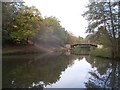
North Downs Way footbridge over River Wey
Note the sand slopes to the left of the picture
Image: © Keith Rose
Taken: 12 Nov 2005
0.03 miles
10
The North Downs Way on the outskirts of Guildford
Image: © Dave Kelly
Taken: 13 Apr 2016
0.03 miles