IMAGES TAKEN NEAR TO
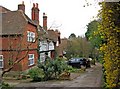
Portsmouth Road, GUILDFORD, GU2 4EB
Introduction
This page details the photographs taken nearby to Portsmouth Road, GU2 4EB by members of the Geograph project.
The Geograph project started in 2005 with the aim of publishing, organising and preserving representative images for every square kilometre of Great Britain, Ireland and the Isle of Man.

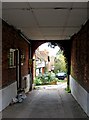
There are currently over 7.5m images from over14,400 individuals and you can help contribute to the project by visiting https://www.geograph.org.uk
Image Map
Images are licensed for reuse under creativecommons.org/licenses/by-sa/2.0
Notes
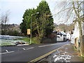
- Clicking on the map will re-center to the selected point.
- The higher the marker number, the further away the image location is from the centre of the postcode.
Image Listing (231 Images Found)
Images are licensed for reuse under creativecommons.org/licenses/by-sa/2.0
Image
Details
Distance
1
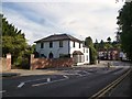
Portsmouth Road, Artington
The white house was the Anchor and Hope, also known as the St Catherine's Inn, until 1936.
Image: © David960
Taken: 9 Aug 2014
0.01 miles
2
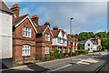
50-62 Portsmouth Road
Early 20th Century terrace built to replace earlier houses on the site.
Image: © Ian Capper
Taken: 1 Jun 2018
0.03 miles
4
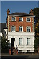
House on Portsmouth Road, Near Guildford, Surrey
Imposing house in what are now the outskirts of Guildford.
Image: © Peter Trimming
Taken: 27 Sep 2009
0.03 miles
5
Entrance to The Valley, St. Catherine's, Guildford
The entrance to the short residential road, known as The Valley, is through this carriage arch of a house in Portsmouth Road, next door to Ye Olde Ship Inn. It would appear from old photographs, that at one time the house with the carriage arch was also a public house or inn.
Image: © P L Chadwick
Taken: 10 Mar 2011
0.04 miles
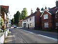
6
The Valley, St. Catherine's, Guildford
A short residential road, probably late Victorian. Nos. 1 to 8 may be by the architect Norman Shaw, who was responsible for Pickards Rough, in nearby Sandy Lane. The owner of that property, Thomas Powell, is believed to have developed The Valley.
Image
Image: © P L Chadwick
Taken: 10 Mar 2011
0.04 miles
7
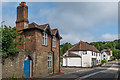
66 and 64 Portsmouth Road
Two buildings either side of Sandy Lane at its junction with Portsmouth Road. No 64, the one beyond the junction, dates from the 17th Century and is grade II listed - see www.historicengland.org.uk/listing/the-list/list-entry/1377894. Around the turn of the 19th/20th Century, no 66 was a coffee house.
Image: © Ian Capper
Taken: 1 Jun 2018
0.04 miles
8
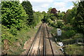
Portsmouth line railway from Ferry Lane bridge
This stretch of railway south of Guildford station is located between two tunnels. Viewed from the bridge at Ferry Lane on the Pilgrims Way/North Downs Way.
Image: © Paul E Smith
Taken: 15 May 2010
0.05 miles
9
Road narrowing as it descends down St Catherine's Hill
Image: © Basher Eyre
Taken: 22 Dec 2009
0.05 miles
10
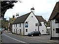
Ye Olde Ship Inn (1), Portsmouth Road, St. Catherine's, Guildford
The pub has been operating here since 1566, when Queen Elizabeth I was on the throne. The building has undoubtedly changed considerably since then. Over the years it has had various names. In the 18th century its names included the Red Lyon, The Ship, The White Lyon and the King's Arms. By the 19th century it has reverted to The Ship, and by 1900 it was known by its present name, possibly to distinguish it from at least one other Ship in the Guildford area.
Image
Image
Image: © P L Chadwick
Taken: 10 Mar 2011
0.05 miles