IMAGES TAKEN NEAR TO
Portsmouth Road, GUILDFORD, GU2 4DX
Introduction
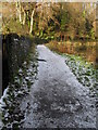
This page details the photographs taken nearby to Portsmouth Road, GU2 4DX by members of the Geograph project.
The Geograph project started in 2005 with the aim of publishing, organising and preserving representative images for every square kilometre of Great Britain, Ireland and the Isle of Man.

There are currently over 7.5m images from over14,400 individuals and you can help contribute to the project by visiting https://www.geograph.org.uk
Image Map
Images are licensed for reuse under creativecommons.org/licenses/by-sa/2.0
Notes
- Clicking on the map will re-center to the selected point.
- The higher the marker number, the further away the image location is from the centre of the postcode.
Image Listing (245 Images Found)
Images are licensed for reuse under creativecommons.org/licenses/by-sa/2.0
Image
Details
Distance
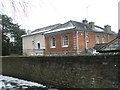
1
Portsmouth Road, Artington
The white house was the Anchor and Hope, also known as the St Catherine's Inn, until 1936.
Image: © David960
Taken: 9 Aug 2014
0.03 miles
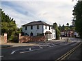
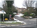
2
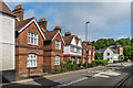
House on Portsmouth Road, Near Guildford, Surrey
Imposing house in what are now the outskirts of Guildford.
Image: © Peter Trimming
Taken: 27 Sep 2009
0.05 miles
3
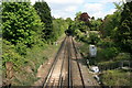
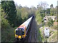
Portsmouth line railway from Ferry Lane bridge
This stretch of railway south of Guildford station is located between two tunnels. Viewed from the bridge at Ferry Lane on the Pilgrims Way/North Downs Way.
Image: © Paul E Smith
Taken: 15 May 2010
0.05 miles
6
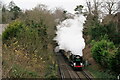
'Clan Line'
No.35028 'Clan Line' with the British Pullman 'Christmas Lunch' circular tour from Victoria, via Guildford and Redhill. Seen just south of Guildford, from Ferry Lane bridge.
Image: © Peter Trimming
Taken: 11 Dec 2021
0.06 miles
7
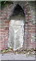
Old Milestone by the A3100, Portsmouth Road, Guildford Parish
Carved stone post by the A3100 (was A3), in parish of Guildford (Guildford District), Portsmouth Road, opposite Rivermount Gardens, set in stone wall with brick edges, behind pavement, on West side of road. Guildford facets, erected by the Kingston & Sheetbridge, 1st District turnpike trust in the 19th century. Photo from 2020 https://www.facebook.com/groups/MilestoneSociety/permalink/9252822874755247/?app=fbl
Inscription reads:- : (HYDE PARK CORNER) / 28 : : (PORTSMOUTH / 41) :
Carved benchmark on right face.
Milestone Society National ID: SY_LP28
Image: © HK Coleman
Taken: 20 Mar 2005
0.07 miles
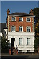
8
50-62 Portsmouth Road
Early 20th Century terrace built to replace earlier houses on the site.
Image: © Ian Capper
Taken: 1 Jun 2018
0.07 miles
9
Next Stop Guildford
Portsmouth to London train heading into the tunnel before Guildford Station. The tunnel cuts through the spur of the North Downs on the western bank of the Wey Gap.
Image: © Colin Smith
Taken: 20 Apr 2008
0.07 miles