IMAGES TAKEN NEAR TO
Hookstone Lane, WOKING, GU24 9QP
Introduction
This page details the photographs taken nearby to Hookstone Lane, GU24 9QP by members of the Geograph project.
The Geograph project started in 2005 with the aim of publishing, organising and preserving representative images for every square kilometre of Great Britain, Ireland and the Isle of Man.

There are currently over 7.5m images from over14,400 individuals and you can help contribute to the project by visiting https://www.geograph.org.uk
Image Map
Images are licensed for reuse under creativecommons.org/licenses/by-sa/2.0
Notes
- Clicking on the map will re-center to the selected point.
- The higher the marker number, the further away the image location is from the centre of the postcode.
Image Listing (14 Images Found)
Images are licensed for reuse under creativecommons.org/licenses/by-sa/2.0
Image
Details
Distance
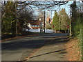
1
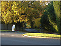
Hookstone Lane
The view down Hookstone Lane from its junction with the A319, Bagshot Road.
Image: © Alan Hunt
Taken: 11 Nov 2012
0.06 miles
3
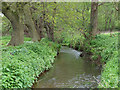
Windle Brook
The stream flows eastwards from Windlesham before joining forces with Clappers Brook to form Mill Bourne.
Image: © Andrew Smith
Taken: 6 May 2006
0.16 miles
5
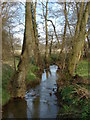
The Hale Bourne
A view of the Hale bourne running towards Chobham where it becomes the Mill Bourne. The fence in the background is the boundary of Little Owl Farm.
Image: © Alan Hunt
Taken: 24 Mar 2011
0.19 miles
6
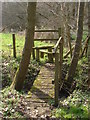
Hookstone Farm
The footbridge and stile from the fields of Hookstone Farm to the woods to the north
Image: © Alan Hunt
Taken: 24 Mar 2011
0.20 miles
7
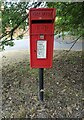
Elizabeth II postbox on Bagshot Road, West End
Postbox No. GU24 6.
Image: © JThomas
Taken: 25 Jul 2022
0.20 miles
8
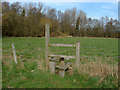
Hookstone Farm
Stile on footpath 40 in the fields of Hookstone Farm
Image: © Alan Hunt
Taken: 24 Mar 2011
0.20 miles
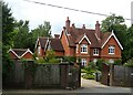
9
Church Lane, West End
A view along Church Lane towards its junction with the A319, the Bagshot Road. The house in view is the Old Forge, on the north side of the A319.
Image: © Alan Hunt
Taken: 19 Feb 2012
0.20 miles
10
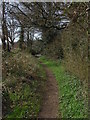
Coldharbour lane, West End
This short stretch of unmade footpath runs from the A319 to the tarmaced part of Coldharbour Lane
Image: © Alan Hunt
Taken: 24 Mar 2011
0.20 miles