IMAGES TAKEN NEAR TO
Tithe Lane, WOKING, GU24 9FY
Introduction
This page details the photographs taken nearby to Tithe Lane, GU24 9FY by members of the Geograph project.
The Geograph project started in 2005 with the aim of publishing, organising and preserving representative images for every square kilometre of Great Britain, Ireland and the Isle of Man.

There are currently over 7.5m images from over14,400 individuals and you can help contribute to the project by visiting https://www.geograph.org.uk
Image Map
Images are licensed for reuse under creativecommons.org/licenses/by-sa/2.0
Notes
- Clicking on the map will re-center to the selected point.
- The higher the marker number, the further away the image location is from the centre of the postcode.
Image Listing (62 Images Found)
Images are licensed for reuse under creativecommons.org/licenses/by-sa/2.0
Image
Details
Distance
1
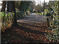
Fairfield Lane
The access road off Benner lane that ends in a footpath running to the A319 by Brook Place.
Image: © Alan Hunt
Taken: 16 Jan 2015
0.06 miles
2
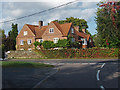
Derelict house, West End
A boarded up house off Streets Heath in West End, presenting a wonderful renovation project in a prime location for some enterprising soul.
Image: © Alan Hunt
Taken: 22 Mar 2016
0.07 miles
3

Streets Heath, West End
A large bush on the triangle at the junction of Streets Heath with Benner Lane.
Image: © Alan Hunt
Taken: 22 Mar 2016
0.07 miles
4
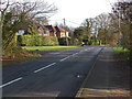
Benner lane, West End
Looking south along Benner Lane towards the junction with Fairfield Lane. The wooded area of Streets Heath is on the left.
Image: © Alan Hunt
Taken: 16 Jan 2015
0.07 miles
5
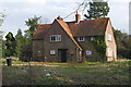
Malthouse Farm
The grade II listed C16th century farmhouse with later additions on Benner Lane, West End.
Image: © Alan Hunt
Taken: 8 Oct 2014
0.08 miles
6

Benner Lane, West End
The junction with the access road to the houses along the east of Streets Heath.
Image: © Alan Hunt
Taken: 22 Mar 2016
0.09 miles
8
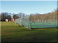
West End tennis courts
The tennis courts on the Streets Heath recreation ground with the Tringham Hall in the background.
Image: © Alan Hunt
Taken: 16 Jan 2015
0.13 miles
9
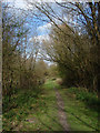
Footpath, Westend
View along the footpath from the end of Fairfield Lane to Brook Place
Image: © Alan Hunt
Taken: 11 Apr 2010
0.13 miles
10

Streets Heath, West End
The road running from the High Street to Benner Lane.
Image: © Alan Hunt
Taken: 22 Mar 2016
0.13 miles