IMAGES TAKEN NEAR TO
Flexlands Place, WOKING, GU24 8BG
Introduction
This page details the photographs taken nearby to Flexlands Place, GU24 8BG by members of the Geograph project.
The Geograph project started in 2005 with the aim of publishing, organising and preserving representative images for every square kilometre of Great Britain, Ireland and the Isle of Man.

There are currently over 7.5m images from over14,400 individuals and you can help contribute to the project by visiting https://www.geograph.org.uk
Image Map
Images are licensed for reuse under creativecommons.org/licenses/by-sa/2.0
Notes
- Clicking on the map will re-center to the selected point.
- The higher the marker number, the further away the image location is from the centre of the postcode.
Image Listing (13 Images Found)
Images are licensed for reuse under creativecommons.org/licenses/by-sa/2.0
Image
Details
Distance
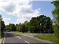
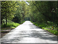
2
Sandpit Hall Road
Straight road on the edge of Chobham.
Image: © David Howard
Taken: 1 Mar 2009
0.11 miles

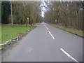
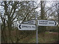
4
Station Road junction with Sandpit Hall Road
Image: © Stuart Logan
Taken: 20 Apr 2012
0.14 miles
5
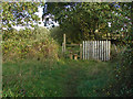
Stile and fence near Chobham
A stile on the footpath running east from the car park near the cricket ground.
Image: © Alan Hunt
Taken: 21 Oct 2014
0.14 miles
7
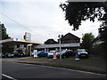
Leonard Daborn garage, Chobham
As expected you can't see many actual MGs or Rovers. MGs are being made again in 2013 but they are no longer British.
Image: © David Howard
Taken: 1 Sep 2013
0.17 miles
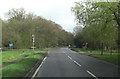
8
Sandpit Hall Road, Chobham
East of its junction with the A3046.
Image: © Andrew Smith
Taken: 6 May 2006
0.19 miles
9
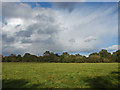
Fields near Chobham
The fields to the east of Chobham with a fine example of an anvil cloud to the north.
Image: © Alan Hunt
Taken: 21 Oct 2014
0.19 miles
10
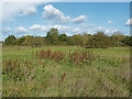
Fields near Chobham
Rough pasture to the east of Chobham village. These old watermeadows on the floodplain of the Mill Bourne have numerous footpaths running through them.
Image: © Alan Hunt
Taken: 21 Oct 2014
0.23 miles