IMAGES TAKEN NEAR TO
Chapel Lane, WOKING, GU24 0JY
Introduction
This page details the photographs taken nearby to Chapel Lane, GU24 0JY by members of the Geograph project.
The Geograph project started in 2005 with the aim of publishing, organising and preserving representative images for every square kilometre of Great Britain, Ireland and the Isle of Man.

There are currently over 7.5m images from over14,400 individuals and you can help contribute to the project by visiting https://www.geograph.org.uk
Image Map (Loading...)


Getting Data...Please wait
Leaflet Map data © OpenStreetMap
Images are licensed for reuse under creativecommons.org/licenses/by-sa/2.0
Notes
- Clicking on the map will re-center to the selected point.
- The higher the marker number, the further away the image location is from the centre of the postcode.
Image Listing (28 Images Found)
Images are licensed for reuse under creativecommons.org/licenses/by-sa/2.0
Image
Details
Distance
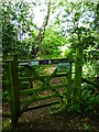
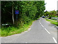
1
Footpath reaches Chapel Lane
The footpath sign is seen next to a sign for a bridleway taking a different direction.
Image: © Shazz
Taken: 27 Jul 2014
0.01 miles
2
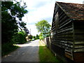
Chapel Lane
View along Chapel Lane, Pirbright.
Image: © Paul E Smith
Taken: 13 Sep 2009
0.02 miles
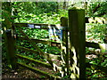
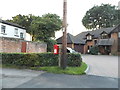
5
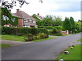
Chapel Lane
Residential Pirbright - large detached houses with big gardens and grassy verges.
Image: © Colin Smith
Taken: 15 Jun 2008
0.05 miles
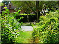
7

Pirbright Common
A small area of the common with Brookwood Cemetery, out of picture, to the right.
Image: © Peter Trimming
Taken: 29 Jun 2019
0.07 miles
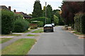
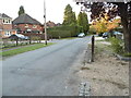
8
Looking east on Chapel Lane from the junction with Cemetery Pales
Image: © Shazz
Taken: 27 Jul 2014
0.10 miles