IMAGES TAKEN NEAR TO
Ash Road, WOKING, GU24 0BG
Introduction
This page details the photographs taken nearby to Ash Road, GU24 0BG by members of the Geograph project.
The Geograph project started in 2005 with the aim of publishing, organising and preserving representative images for every square kilometre of Great Britain, Ireland and the Isle of Man.

There are currently over 7.5m images from over14,400 individuals and you can help contribute to the project by visiting https://www.geograph.org.uk
Image Map
Images are licensed for reuse under creativecommons.org/licenses/by-sa/2.0
Notes
- Clicking on the map will re-center to the selected point.
- The higher the marker number, the further away the image location is from the centre of the postcode.
Image Listing (27 Images Found)
Images are licensed for reuse under creativecommons.org/licenses/by-sa/2.0
Image
Details
Distance
1
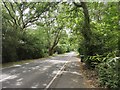
Entering Pirbright
Heading north along Guildford Road into the village. Behind the copper beech is a small pond.
Image: © Colin Smith
Taken: 15 Jun 2008
0.05 miles
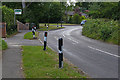
2
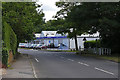
Guildford Road, Pirbright
The Volvo salesroom on the Guildford Road on the outskirts of Pirbright with Mill Lane on the right.
Image: © Alan Hunt
Taken: 25 Jul 2015
0.10 miles
4
Mill Lane, Pirbright
Looking west along Mill Lane with the junction of Rapley's Field on the left.
Image: © Alan Hunt
Taken: 25 Jul 2015
0.12 miles
5
Cove Bridge, Pirbright
The bridge carrying the Guildford road over the Hodge Brook by the junction with Mill Lane.
Image: © Alan Hunt
Taken: 25 Jul 2015
0.13 miles
6
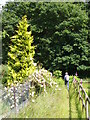
Footpath at Pirbright
Good going here over the sandy surface on the southern edge of Pirbright. Not quite quiet due to the proximity of the army ranges.
Image: © Colin Smith
Taken: 15 Jun 2008
0.15 miles
7
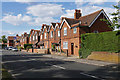
Guildford Road, Pirbright
The late Victorian terrace on the east side of Guildford Road, Pirbright.
Image: © Alan Hunt
Taken: 25 Jul 2015
0.17 miles
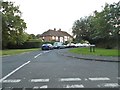
8
Aldershot Road
Main road the A324 heading south.
Image: © James Emmans
Taken: 4 Jun 2020
0.20 miles
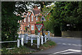
9
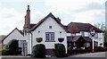
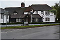
The White Hart, Pirbright
The White Hart pub, which has stood on this corner since the mid 1600s. It used to contain a vast amount of agricultural equipment, which was cleaned out by new owners who renamed it "The Moorhen". Another change of ownership has re-established the original name.
Image: © Len Williams
Taken: 15 Apr 2012
0.21 miles