IMAGES TAKEN NEAR TO
Riverside Close, WOKING, GU24 0AP
Introduction
This page details the photographs taken nearby to Riverside Close, GU24 0AP by members of the Geograph project.
The Geograph project started in 2005 with the aim of publishing, organising and preserving representative images for every square kilometre of Great Britain, Ireland and the Isle of Man.

There are currently over 7.5m images from over14,400 individuals and you can help contribute to the project by visiting https://www.geograph.org.uk
Image Map
Images are licensed for reuse under creativecommons.org/licenses/by-sa/2.0
Notes
- Clicking on the map will re-center to the selected point.
- The higher the marker number, the further away the image location is from the centre of the postcode.
Image Listing (165 Images Found)
Images are licensed for reuse under creativecommons.org/licenses/by-sa/2.0
Image
Details
Distance
1
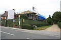
Riverside Close, Brookwood
The old Kingdom Hall Jehovas Witness church (previously Brookwood Methodist Church) has been demolished, being replaced by a new building behind the green fencing, adjacent to Riverside Close.
Image: © Paul E Smith
Taken: 13 Sep 2009
0.01 miles
2
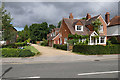
Riverside Close, Brookwood
A short close off Connaught Road in Brookwood.
Image: © Alan Hunt
Taken: 9 Sep 2016
0.03 miles
3
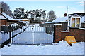
Entrance to Brookwood Memorial Halls
Locked entrance gates to Brookwood Memorial Halls. The sign reads 'NO CARS - Access by footpath only until ice clears from car park and drive'.
Image: © Paul E Smith
Taken: 9 Jan 2010
0.03 miles
4
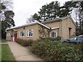
Brookwood Village hall
Brookwood Memorial Hall which is relatively new compared with some. This is also known as the Large Memorial Hall as there is a smaller one next door which is known as the Small Memorial Hall. So Brookwood has two village halls, small and large, adjacent to each other. Image
Image: © Bill Nicholls
Taken: 16 Jan 2011
0.03 miles
5
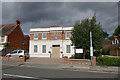
Kingdom Hall, Brookwood
The Kingdom Hall on Connaught Road, Brookwood. This building was constructed in 2009 to replace an older building which once served as a Methodist Chapel. the original building can be seen on Google Streetview by going back to 2008.
Image: © Alan Hunt
Taken: 9 Sep 2016
0.04 miles
7
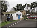
Cars in the carpark
Even on a Sunday the Village hall is in use as can be seen from the carpark.
Image: © Bill Nicholls
Taken: 16 Jan 2011
0.04 miles
8
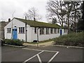
Small Memorial Hall
After some new information I have been told this is the Small Memorial Hall and is the original War Memorial Hall. The larger hall next to it was built later, but this hall remains and is used by a lot of village organisations, hired out for children's parties etc. So Brookwood has two village halls, small and large, adjacent to each other. My thanks to Paul Smith for the information
Image: © Bill Nicholls
Taken: 16 Jan 2011
0.04 miles
9
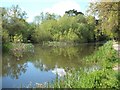
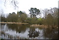
Basingstoke Canal at Brookwood
This is the flash at Brookwood located between Sheet's Heath and Pirbright Bridges. The flash was a semi-circular area which enabled barges to turn when necessary, and has been left untended encouraging wildlife to flourish.
Image: © Paul E Smith
Taken: 26 Apr 2009
0.05 miles
10
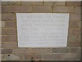
Memorial stone
The memorial stone on Brookwood Village Hall. Image
Image: © Bill Nicholls
Taken: 16 Jan 2011
0.05 miles